DeForest in Dane County, Wisconsin — The American Midwest (Great Lakes)
Site of the First Well in DeForest
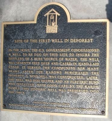
Photographed by William J. Toman, October 30, 2010
1. Site of the First Well in DeForest Marker
Erected 1996 by the Resad Family/Condon Oil Company, the DeForest Area Historical Society, and the Village of DeForest.
Topics. This historical marker is listed in this topic list: Settlements & Settlers.
Location. 43° 14.856′ N, 89° 19.491′ W. Marker is in DeForest, Wisconsin, in Dane County. It is at the intersection of East Holum Street and U.S. 51, on the left when traveling west on East Holum Street. Touch for map. Marker is at or near this postal address: 937 East Holum Street, Deforest WI 53532, United States of America. Touch for directions.

Regionally, this marker is in Southeast Wisconsin and in Greater Madison.
this page online
Other nearby markers. At least 8 other markers are within 6 miles of this marker, measured as the crow flies: De Forest Centennial (approx. 0.8 miles away); The De Forest Depot (approx. 0.8 miles away); Andreas Dahl (approx. one mile away); The Story of the Pink Elephant (approx. 2.8 miles away); Token Creek (approx. 3.9 miles away); Token Creek Sedge Meadow Trail (approx. 4.3 miles away); Ella Wheeler Wilcox (approx. 4.6 miles away); Maureen Mengelt Memorial (approx. 5.2 miles away). Touch for a list and map of all markers in DeForest.
Another marker is no longer nearby. Our Bell (was approx. 0.6 miles away but has been permanently removed).
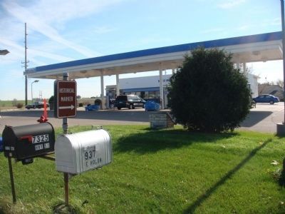
Photographed by William J. Toman, October 30, 2010
2. Site of the First Well in DeForest Marker
The marker is on the other side of the stone base in the center of the photo next to the bush.
Credits. This page was last revised on June 16, 2016. It was originally submitted on November 17, 2010, by William J. Toman of Green Lake, Wisconsin. This page has been viewed 979 times since then and 30 times this year. Photos: 1, 2. submitted on November 17, 2010, by William J. Toman of Green Lake, Wisconsin. • Bill Pfingsten was the editor who published this page.
