Near Darlington in Darlington County, South Carolina — The American South (South Atlantic)
Attempted Ambush
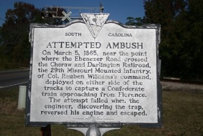
Photographed by Cindy Bullard, November 10, 2010
1. Attempted Ambush Marker
Erected 1975 by Darlington County Historical Commission. (Marker Number 16-12.)
Topics. This historical marker is listed in this topic list: War, US Civil. A significant historical month for this entry is March 1770.
Location. 34° 16.216′ N, 79° 51.069′ W. Marker is near Darlington, South Carolina, in Darlington County. It is on Ebernezer Road, on the right when traveling north. Marker is on the south side of the railroad crossing. Touch for map. Marker is in this post office area: Darlington SC 29532, United States of America. Touch for directions.

Regionally, this marker is in South Carolina’s Pee Dee. It is also in the American South and specifically in the Deep South. Globally, it is in North America, the Western Hemisphere, the Western World, and the
this page online
Other nearby markers. At least 8 other markers are within 3 miles of this marker, measured as the crow flies: Samuel Bacot 1745-1795 (approx. 1.7 miles away); Edmund H. Deas (approx. 1.9 miles away); Macedonia Church (approx. 2.1 miles away); Darlington Memorial Cemetery (approx. 2.2 miles away); Henry "Dad" Brown (approx. 2.2 miles away); Lawrence Reese (approx. 2.3 miles away); "Reese's Row" (approx. 2.3 miles away); First Baptist Church (approx. 2.3 miles away). Touch for a list and map of all markers in Darlington.
Credits. This page was last revised on June 16, 2016. It was originally submitted on November 17, 2010, by David Bullard of Seneca, South Carolina. This page has been viewed 1,879 times since then and 58 times this year. Photo 1. submitted on November 17, 2010, by David Bullard of Seneca, South Carolina. • Craig Swain was the editor who published this page.
