The Plains
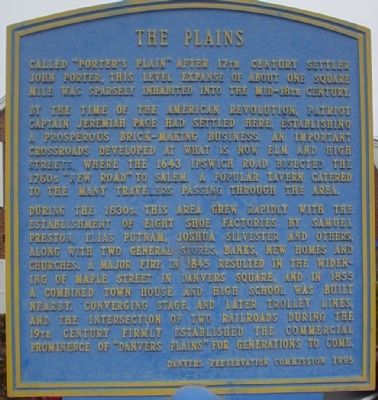
By the time of the American Revolution, patriot Captain Jeremiah Page had settled here, establishing a prosperous brick-making business. An important crossroads developed at what is now Elm and High Streets, where the 1643 Ipswich road bisected the 1760's "New Road" to Salem. A popular tavern catered to the many travelers passing through the area.
During the 1830s this area grew rapidly with the
establishment of eight shoe factories by Samuel
Preston, Elias Putname, Joshua Silvester and others,
along with two general stores, banks, new homes and
churches. A major fire in 1845 resulted in the widening
of Maple street in Danvers square, and in 1855
a combined town house and high school was built
nearby. converging stage, and later trolly lines,
and the intersection of two railroads during the
19th century firmly established the commercial
prominence of "Danvers Plains" for generations to come.
Erected 1995 by Danvers Preservation Commission.
Topics. This historical marker is listed in these topic lists: Colonial Era • Industry & Commerce • Settlements & Settlers. A significant historical year for this entry is 1643.
Location.
Other nearby markers. At least 8 other markers are within 2 miles of this marker, measured as the crow flies. Anne L. Page (about 300 feet away, measured in a direct line); In Commemoration of Arnold's Expedition to Quebec (about 400 feet away); Rebecca Nurse Homestead (approx. 0.8 miles away); Salem Village Witchcraft Victims’ Memorial (approx. 1.1 miles away); Salem Village Meeting House (approx. 1.1 miles away); Danversport (approx. 1.1 miles away); Site of Israel Hutchinson's Home / Israel Hutchinson (approx. 1.1 miles away); Samuel Holten House (approx. 1.2 miles away). Touch for a list and map of all markers in Danvers.
Credits. This page was last revised on June 16, 2016. It was originally submitted on November 23, 2010, by Michael Tiernan of Danvers, Massachusetts. This page has been viewed 809 times since then and 20 times this year. Photos: 1, 2, 3. submitted on November 23, 2010, by Michael Tiernan of Danvers, Massachusetts. • Bill Pfingsten was the editor who published this page.


