Near Fort Oglethorpe in Walker County, Georgia — The American South (South Atlantic)
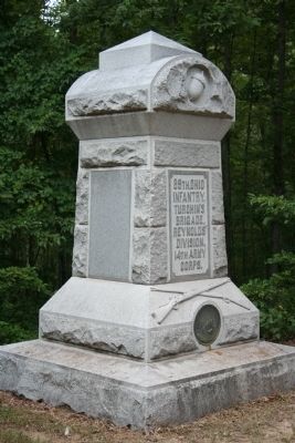
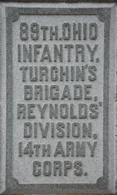
89th Ohio Infantry
Turchin's Brigade - Reynolds' Division
— 14th Army Corps —
Turchin's Brigade,
Reynolds Division,
14th Army Corps.
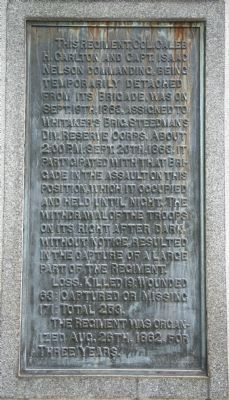
Reverse Side of Marker:
This regiment, Col. Caleb H. Carlton and capt. Isaac Nelson commanding, being temporarily detached from its Brigade, was on Sept. 19th, 1863, assigned to Whitaker's Brig. Steedman's Div. Reserve Corps. About 2:00 P.M. Sept. 20th, 1863, it participated with that Brigade in the assualt on this position, which it occupied and held until night. The withdrawal of the troops on its right after dark, without notice, resulted in the capture of a large part of the Regiment.
Loss, Killed 19; Wounded 63; Captured or Missing 171; Total 253.
The regiment was organized Aug. 26th, 1862, for three years.
Erected 1894 by the State of Ohio. (Marker Number MT-1016.)
Topics. This historical marker is listed in this topic list: War, US Civil. A significant historical month for this entry is September 1935.
Location. 34° 55.633′ N, 85° 16.313′ W. Marker is near Fort Oglethorpe, Georgia, in Walker County. Marker can be reached from Vittetoe Road west of Vittetoe-Chickamauga Road when traveling west. This historical marker is located in the northwest section of the Chickamauga National Military Park, near the Snodgrass Hill area of the driving tour, along the part of the battlefield known as Horseshoe Ridge, more specially on Hill #3 of Horseshoe Ridge. To view this historical marker drive to the parking area for Horseshoe Ridge (just beyond the Snodgrass Hill tour stop) and proceed westward on foot, along the southern crest of the ridge for a little more than 0.2 of a mile, to the high ground on Hill #3. According to the location information provided by the National Park Service the, “Monument located on Snosgrass Hill in the Chickamauga Battlefield, map site #152”. Touch for map. Marker is in this post office area: Fort Oglethorpe GA 30742, United States of America. Touch for directions.
Other nearby markers. At least 8 other markers are within walking distance of this marker. 22nd Michigan Infantry (here, next to this marker); Granger's Headquarters Shell Monument (a few steps from this marker); Whitaker’s Brigade. (a few steps from this marker); 115th Illinois Infantry (a few steps from this marker); 2nd South Carolina Infantry Regiment (a few steps from this marker); 84th Indiana Infantry Regiment (within shouting distance of this marker); 40th Ohio Infantry (within shouting distance of this marker); 21st Ohio Infantry (within shouting distance of this marker). Touch for a list and map of all markers in Fort Oglethorpe.
More about this marker. According to the description information provided by the National Park
Service, the monument is, “7'6" x 7'6" x 11'8" monument with rock-faced base, sloping pedestal, rusticated shaft, and curved-top capstone. Crossed muskets and bronze state seal in base, raised lettering on shaft, acorn in capstone. On Snodgrass Hill.”
The National Park Service also identifies the E. F. Carr Company of Quincy, Massachusetts as being the Architect for this monument.
I used the "Chickamauga Battlefield" map, that I purchased at the Chickamauga and Chattanooga National Military Park, Visitor Center, to determine both the marker number for this monument and the monument's location in relation to the rest of the park's monuments, markers, and tablets. According to the map it provides the, "numerical listing of all monuments, markers, and tablets on the Chickamauga Battlefield (using the Chick-Chatt NMP Monument Numbering System).”
Regarding 89th Ohio Infantry. The 89th Ohio Infantry was part of the forward brigade (Whitaker's Brigade) of Steedman's Division which arrived at the Union position on Snodgrass Hill at the critical moment of the battle. When directed to provide support for the Union right flank, Steedman directed Whitaker's Brigade to rush up to crest of the ridge, arriving just in time to drive off the Confederate forces that were on the verge of flanking the beleaguered 21st
OVI, situated on what had been the extreme right flank of the Union line of battle.
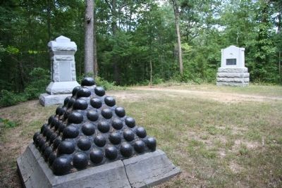
Photographed By Dale K. Benington, July 10, 2010
5. 89th Ohio Infantry Marker
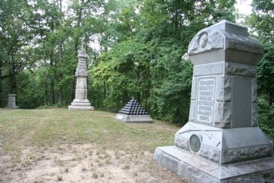
View looking east, from the Headquarters of the Reserve Corp marker, along the southern crest of Snodgrass Hill. The historical marker is in the left background and the trail in the center of the picture leads off into the woods where the 21st OVI was located.
Credits. This page was last revised on October 21, 2020. It was originally submitted on December 19, 2010, by Dale K. Benington of Toledo, Ohio. This page has been viewed 888 times since then and 24 times this year. Photos: 1, 2, 3, 4, 5. submitted on December 19, 2010, by Dale K. Benington of Toledo, Ohio.
