Springfield in Greene County, Missouri — The American Midwest (Upper Plains)
Vietnam War Memorial
Together Then Together Now
| — | Post 639 | — |
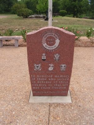
Photographed by Lee Hattabaugh, August 4, 2005
1. Vietnam War Memorial Marker
Erected 1999 by American Legion Post 639.
Topics. This historical marker and memorial is listed in these topic lists: Fraternal or Sororal Organizations • War, Vietnam.
Location. 37° 9.996′ N, 93° 19.831′ W. Marker is in Springfield, Missouri, in Greene County. It can be reached from South Scenic Avenue (Local Road 137) half a mile West Battlefield Road, on the right when traveling north. Monument is on the grounds of American Legion Post 639. Touch for map. Marker is at or near this postal address: 2660 South Scenic Avenue, Springfield MO 65807, United States of America. Touch for directions.

Regionally, this marker and memorial is in the American Ozarks, in the Lewis & Clark Corridor, and in the Corn Belt. Globally, it is in North America, the Western Hemisphere, the Western World, and the Anglosphere. Historically, it finds itself in what was once the territory of the Mississippian Culture, the Louisiana Purchase, and the Antebellum South.
Other nearby markers. At
this page online
Credits. This page was last revised on June 16, 2016. It was originally submitted on December 19, 2010, by Lee Hattabaugh of Capshaw, Alabama. This page has been viewed 990 times since then and 22 times this year. Photo 1. submitted on December 19, 2010, by Lee Hattabaugh of Capshaw, Alabama. • Craig Swain was the editor who published this page.
