Near Williamsport in Washington County, Maryland — The American Northeast (Mid-Atlantic)
Shielding the Army
Where are the Confederates?
| — | Gettysburg Campaign | — |
Photographed by Robert H. Moore, II, December 27, 2010
1. Shielding the Army Marker
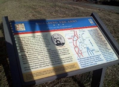
“We have outmaneuvered [Gen. Joseph] Hooker," exclaimed an optimistic Lee to Gen. Isaac R. Trimble, a Marylander. “He doesn’t know where we are or what our plans are. Our whole army will be in Pennsylvania… leaving the enemy far behind and obliged to follow us by forced marches. I hope with these advantages to accomplish some signal result and to end the war, if Providence favors us.”
Once it became apparent an invasion was underway, an alarmed Lincoln administration responded by calling for 100,000 militiamen from Pennsylvania, Ohio, and West Virginia to respond to the emergency.
(Sidebar 1):
The mountains also sheltered local citizens who were afraid of the Confederates. Wagon trains of civilians fled
this page online
(Sidebar 2):
“All the country through which we passed today is beautiful and rich, splendid wheat, hay and corn crops. Nearly all the people are Union.” – Robin Berkeley, Confederate artilleryman.
(Sidebar 3):
Randolph Shotwell of Pickett’s Division later remembered the hardship of the long march: “By three o’clock we have traveled twenty miles, but now the sultry sun fairly scorches our blistered backs; our brains seem addled; and the weight of the heavy musket has worn first one shoulder then the other into a red heat blister under the saturated jacket and shirt; and our poor legs seem utterly unable to take another step!”
Erected by Maryland Civil War Trails.
Topics and series. This historical marker is listed in these topic lists: African Americans • War, US Civil. In addition, it is included in the Maryland Civil War Trails series list.
Location. Marker is missing. It was
Photographed by Robert H. Moore, II, December 27, 2010
2. Shielding the Army Marker

Regionally, this marker was in Western Maryland. It was also in the American Mid-Atlantic, in Appalachia, and specifically in Northern Appalachia. Globally, it was in North America, the Western Hemisphere, the Western World, and the Anglosphere. Historically, it found itself in what was once one of the original Thirteen Colonies.
Other nearby markers. At least 8 other markers are within 3 miles of this location, measured as the crow flies: Wilson Bridge (approx. 2.4 miles away); General J. E. B. Stuart (approx. 2½ miles away); a different marker also named Wilson Bridge (approx. 2½ miles away); One of Lee’s Ammunition Trains (approx. 2.6 miles away); Gettysburg Campaign (approx. 2.7 miles away); Wilson’s Store (approx. 2.7 miles away); “The Bank Road” (approx. 2.7 miles away); Springfield Farm (approx. 2.9 miles away). Touch for a list and map of all markers in Williamsport.
Additional commentary.
1. Marking is Missing
Visited July 5, 2026, Marker is completely missing.
— Submitted July 5, 2026, by Thomas Corwin of Fairfax, Virginia.
Credits. This page was last revised on August 4, 2026. It was originally submitted on December 27, 2010, by Robert H. Moore, II of Winchester, Virginia. This page has been viewed 1,404 times since then and 30 times this year. Photos: 1, 2. submitted on December 27, 2010, by Robert H. Moore, II of Winchester, Virginia. • Craig Swain was the editor who published this page.
