Near Gretna in Sarpy County, Nebraska — The American Midwest (Upper Plains)
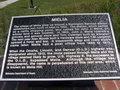
Melia
When the Omaha, Lincoln, and Denver (O.L.D.) highway was designated about 1913, the route passed through Melia and the village seemed likely to grow. U.S. Highway 6, the successor to the O.L.D., bypassed Melia. Although the village has disappeared, the name is perpetuated at this rest area, which is known as Melia Hill.
Erected by Nebraska Department of Roads & Nebraska State Historical Society.
Topics. This historical marker is listed in these topic lists: Landmarks • Settlements & Settlers. A significant historical year for this entry is 1902.
Location. 41° 5.065′ N, 96° 16.526′ W. Marker is near Gretna, Nebraska, in Sarpy County. Marker can be reached from Interstate 80 at milepost 431, on the right when traveling west. Marker is in the Melia Hill Rest Area. Touch for map. Marker is in this post office area: Gretna NE 68028, United States of America. Touch for directions.
Other nearby markers. At least 8 other markers are within 15 miles of this marker, measured as the crow flies. Native Americans in the Lower Platte Valley (a few steps from this marker); The Ox-Bow Trail (approx. 5.3 miles away); In Honor Of John McBride Belnap (approx. 5.6 miles away); Platte River (approx. 6.1 miles away); The Armour and Company Icehouse (approx. 8.4 miles away); Right Reverend Monsignor Edward J. Flanagan (approx. 14.3 miles away); Boys Town Veterans Memorial (approx. 14.3 miles away); Msgr. Edward Joseph Flanagan (approx. 14.3 miles away).

Photographed By Christopher Light, July 16, 2007
2. Interstate 50 Years
In Appreciation of those who dedicated their lives to designing, building, maintainng and patrolling our Interstate System, so that all motorist may enjoy safe and efficient mobility.
AAA Nebraska
Monument Dedicated on June 22, 2006 in celebration of the 50th Anniversary of the Interstate System.
State of Nebraska.
Credits. This page was last revised on June 16, 2016. It was originally submitted on August 23, 2007, by Christopher Light of Valparaiso, Indiana. This page has been viewed 2,281 times since then and 54 times this year. Last updated on January 15, 2011, by James R. Kuntz of Warrenton, Missouri. Photos: 1, 2. submitted on August 23, 2007, by Christopher Light of Valparaiso, Indiana. • Kevin W. was the editor who published this page.
