Savannah in Andrew County, Missouri — The American Midwest (Upper Plains)
Andrew County
Inscription.
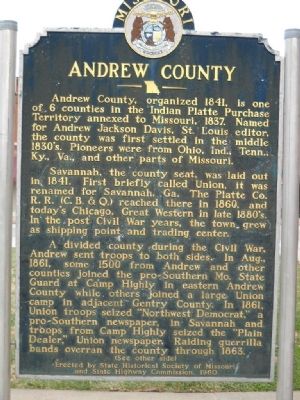
Andrew County, organized 1841, is one of 6 counties in the Indian Platte Purchase Territory annexed to Missouri, 1837. Named for Andrew Jackson Davis, St. Louis editor, the county was first settled in the middle 1830ís. Pioneers were from Ohio, Ind., Tenn., Ky., Va., and other parts of Missouri.
Savannah, the county seat, was laid out in 1841. First briefly called Union, it was renamed for Savannah, Ga., The Platte Co. R. R. (C. B. & Q.) reached therein 1860, and todayís Chicago, Great Western in late 1880ís. In the post Civil War years, the town grew as shipping point and trading center.
A divided county during the Civil War, Andrew sent troops to both sides. In Aug., 1861, some 1500 from Andrew and other counties joined the pro-Southern Mo. State Guard at Camp Highly in eastern Andrew County while others joined a large Union camp in adjacent Gentry County. In 1861, Union troops seized “Northwest Democrat,” a pro-Southern newspaper, in Savannah and troops from Camp Highly seized the “Plain Dealer,” Union newspaper. Raiding guerrilla bands overran the county through 1863.
(see other side)
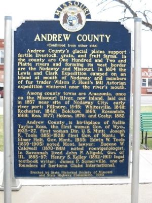
Andrew Countyís glacial plains support fertile livestock, grain, and fruit farms. In the county are One Hundred and Two and Platte rivers and forming its west border are the Nodaway and Missouri. In 1804 the Lewis and Clark Expedition camped on an island at mouth of the Nodaway and members of fur trader Wilson P. Huntís 1811 Astorian expedition wintered near the riverís mouth.
Among county towns are Amazonia, once on the Missouri River, now inland, laid out in 1857 near site of Nodaway City, early river port; Fillmore, 1845; Whitesville, 1848; Rochester, 1848; Bolckow, 1868; Rosendale, 1869; Rea, 1877; Helena, 1878; and Cosby, 1882.
Andrew County is birthplace of Nellie Tayloe Ross, the first gov. of Wyo., 1925-1927, first Woman Dir. U.S. Mint; Joseph K. Toole (1851-1929) first Gov. of Mont.; W. Elmer Holt, Gov. Mont. 1935; Edwin W. Toole (1839 – 1905) noted Mont. Lawyer; Eugene W. Caldwell (1870 – 1918)noted roentgenologist. In Savannah lived John P. Altgeld, Gov. of Ill. 1893-97; Henry S. Kelly (1832 – 1911) legal textbook writer; James P. Somerville, one of founders of Sertoma Clubs International.
Erected 1960 by State Historical Society of Missouri and State Highway Commission.
Topics and series. This historical marker is listed in these topic lists: Settlements & Settlers • War, US Civil. In addition, it is included in the Missouri, The State Historical Society of series list. A significant historical month for this entry is August 1861.
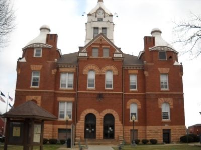
Location. 39° 56.52′ N, 94° 49.802′ W. Marker is in Savannah, Missouri, in Andrew County. There is plenty of parking around the courthouse square. The marker is located on the north side of the Courthouse. Touch for map. Marker is at or near this postal address: 401 North Court Street, Savannah MO 64485, United States of America. Touch for directions.
Other nearby markers. At least 8 other markers are within 12 miles of this marker, measured as the crow flies. Conglomerate Rock (about 300 feet away, measured in a direct line); First Christian Church (about 500 feet away); Christian Church in Savannah, Missouri (about 600 feet away); Lovers Lane, Saint Jo (approx. 10.4 miles away); "Espyd. a wolf" (approx. 10.9 miles away in Kansas); The Lewis and Clark Expedition (approx. 11.4 miles away); William Mitchelhill (approx. 11Ĺ miles away); David Johnson Heaton (approx. 11Ĺ miles away). Touch for a list and map of all markers in Savannah.
Credits. This page was last revised on March 6, 2020. It was originally submitted on January 17, 2011, by Thomas Onions of Olathe, Kansas. This page has been viewed 1,339 times since then and 78 times this year. Photos: 1, 2, 3. submitted on January 17, 2011, by Thomas Onions of Olathe, Kansas.


