Triangle in Prince William County, Virginia — The American South (Mid-Atlantic)
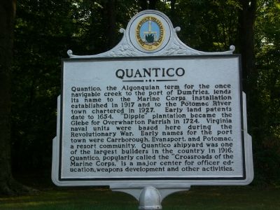
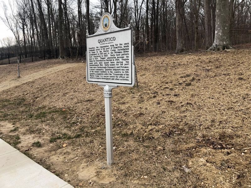
Quantico
Erected 2001 by Prince William County Historical Commission. (Marker Number 17.)
Topics and series. This historical marker is listed in these topic lists: Colonial Era • Settlements & Settlers. In addition, it is included in the Virginia, Prince William County Historical Commission series list. A significant historical year for this entry is 1917.
Location. 38° 32.729′ N, 77° 20.151′ W. Marker is in Triangle, Virginia, in Prince William County. Marker is on Fuller Road (County Route 619) 0.1 miles east of Jefferson Davis Highway (U.S. 1), on the right when traveling east. Marker is near one of the small, original Felix de Weldon Iwo Jima monuments. Also nearby is the new National Museum of the Marine Corps and the Quantico National Cemetery with its flag-girted Avenue of honor. Touch for map. Marker is in this post office area: Triangle VA 22172, United States of America. Touch for directions.
Other nearby markers. At least 8 other markers are within walking distance of this marker. Iwo Jima (within shouting distance of this marker); Kwanzan Cherry Tree (approx. ¼ mile away); Molly Marine (approx. ¼ mile away); The Boys of '67 (approx. ¼ mile away); Semper Fidelis Memorial Park (approx. ¼ mile away); 5th USMC Officers Basic Class 1948 (approx. ¼ mile away); G-3-1 (approx. ¼ mile away); Dedicated to The China Marine (approx. 0.3 miles away). Touch for a list and map of all markers in Triangle.
More about this marker. There is a pull-off lane for drivers to park and visit the nearby Iwo Jima monument.
Regarding Quantico. Spaniards visited Quantico 40 years before Jamestown was settled and Captain John Smith explored the Potomac banks in 1608.
In 1654, the first land patents for the Quantico area were given to English settlers. Tobacco was the main product of early Scottish settlers in the Quantico area, which was also the home of many Revolutionary War heroes. During the Revolutionary War, land and water routes were used heavily
During the Civil War, Confederates used the Potomac’s banks as gun positions to halt Union traffic on the river, protecting Manassas Junction to the west and Fredericksburg to the south. Batteries were established at Evansport (now downtown Quantico, consisted of two batteries on the river bank, and another 400 yards inland), a CSA field battery located at the mouth of Chopawamsic Creek where it empties to the Potomac (now the Marine Corps Air Facility), Shipping Point (Hospital Point on Quantico, number of guns unknown). Batteries were also set up nearby on Freestone Point (A CSA four-gun battery on the shore of the Potomac River, now within Leesylvania State Park), and Cockpit Point (near the current asphalt plant, consisted of six guns (one heavy gun) in three batteries, a powder magazine, and rear rifle pits, on top of a 75-foot high cliff known as Possum Nose).
At the turn of the century, the Quantico Company was formed on Quantico Creek. The company, which promoted the town as a tourist and excursion center, set up tourist sites, such as refreshment stands, boats, and beaches with dressing rooms to promote business. It was also home to a shipyard, one of the main industries in the area before World War I. This village became Quantico because of the location to the Quantico creek and the promotional efforts of the Quantico Company.
While the Town of Quantico was rapidly growing as a fishing village, excursion center and a shipbuilding center in early 1917, the town was not large or significant, and was suffering many financial difficulties. With poor sales, and the onset of World War I, the land surrounding the town was sold to the government in 1918. Quantico still holds its claim to fame as the only town in the country completely surrounded by a military base.
The commandant of the Marine Corps established Marine Barracks, Quantico, on May 14, 1917. Thousands were trained during World War I, including units of the 4th Marine Brigade. In 1920, Marine Corps Schools was founded (in the words of then chief of staff for Quantico, Colonel Smedley D. Butler) to “make this post and the whole Marine Corps a great university.”
Also see . . .
1. Setting up the Batteries. Article discusses constructing Confederate batteries at Evansport (now Quantico, Freestone Point (Leesylvania State Park), Shipping Point (Hospital Point on Quantico), and Cockpit Point (??) “to close the Potomac River to shipping and isolate Washington D.C. By mid-December (1861), the Confederates have 37 heavy guns in position along the river.” (Submitted on August 25, 2007, by Kevin W. of Stafford, Virginia.)
2. The Batteries on the Potomac - Evansport. Link is a page from Harper’s Weekly dated November 23, 1861. It has a sketch of the Evansport, Shipping Point, Cockpit Point confederate batteries. (Submitted on August 26, 2007, by Kevin W. of Stafford, Virginia.)
3. The “Seminole” and the “Pocahontas”engaging the Rebel batteries at Evansport. Link is a page from Harper’s Weekly dated November 2, 1861. It has a sketch of the Seminole and the Pocahontas firing on Evansport, as well as a link to the accompanying article. (Submitted on August 26, 2007, by Kevin W. of Stafford, Virginia.)
4. Marine Corps University. Marine Corps University was founded on 1 August 1989 by order of the Commandant of the Marine Corps, General Alfred M. Gray. Its schools claim a much longer history... (Submitted on August 26, 2007, by Kevin W. of Stafford, Virginia.)
5. Quantico shipyard in 1916. Page 22 of this 1998 illustrated monograph by Debrarae Karnes includes a picture of the Quantico Shipyard. (Large PDF file on slow server. Be patient and document will appear.) (Submitted on August 27, 2007, by Kevin W. of Stafford, Virginia.)
6. The Rebel Batteries on the Potomac now in possession of our troops. Cockpit Point, Shipping Point and Evansport Batteries, after Union Capture, from Harper’s Weekly article published March 22, 1862. Article (Column Four, bottom right) includes link to sketches of the batteries. (Submitted on August 27, 2007, by Kevin W. of Stafford, Virginia.)
Credits. This page was last revised on March 12, 2021. It was originally submitted on August 16, 2007, by Kevin W. of Stafford, Virginia. This page has been viewed 2,923 times since then and 121 times this year. Last updated on February 5, 2011. Photos: 1. submitted on August 16, 2007, by Kevin W. of Stafford, Virginia. 2. submitted on March 12, 2021, by Devry Becker Jones of Washington, District of Columbia.

