Minden in Douglas County, Nevada — The American Mountains (Southwest)
Cradlebaugh Bridge
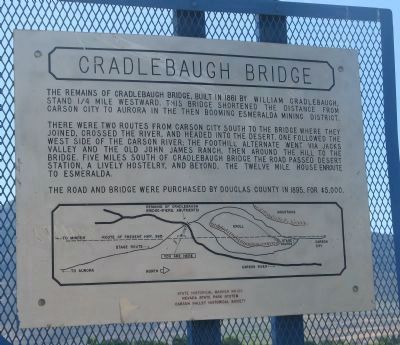
There were two routes from Carson City south to the bridge where they joined, crossed the river, and headed into the desert. One followed the west side of the Carson River; the foothill alternate went via Jacks Valley and the old John James Ranch, then around the hill to the bridge. Five miles south of Cradlebaugh Bridge the road passes Desert Station, a lively hostelry, and beyond, the Twelve Mile House enroute to Esmeralda.
The road and bridge were purchased by Douglas County in 1895, for $5,000.
Erected by the Nevada State Park System and the Carson Valley Historical Society. (Marker Number 123.)
Topics. This historical marker is listed in this topic list: Bridges & Viaducts. A significant historical year for this entry is 1861.
Location. 39° 2.878′ N, 119° 46.794′ W. Marker is in Minden, Nevada, in Douglas County. Marker is on U.S. 395, 1½ miles north of Stephanie Lane, on the right when traveling south. The marker is located just south of the new Cradlebaugh Bridge approximately 9 miles south of Carson City. Touch for map. Marker is in this post office area: Minden NV 89423, United States of America. Touch for directions.
Other nearby markers. At least 8 other markers are within 5 miles of this marker, measured as the crow flies. Carson Trail - Entering Carson Valley (approx. 1½ miles away); Nevada's Birthplace (approx. 3.6 miles away); Old Mormon Station (approx. 3.8 miles away); Boyd Toll Road (approx. 4.2 miles away); We Salute John “Snowshoe” Thompson / A Tribute From Three Lutheran Churches (approx. 4.3 miles away); John A. “Snow-Shoe” Thompson (approx. 4.3 miles away); Hanging Tree (approx. 4½ miles away); Eggs for Sale! (approx. 4.6 miles away). Touch for a list and map of all markers in Minden.
Regarding Cradlebaugh Bridge. The new bridge on US 395 was named to commemorate William Cradlebaugh who built the first bridge across the Carson River in the Carson Valley in 1861. It was located on the Cradlebaugh Toll Road. A post office, also named Cradlebaugh operated for two brief periods, from April 10, 1895 until September 26, 1896 and again from August 22, 1898 until January 15, 1900.
William Cradlebaugh was the younger brother of John Cradlebaugh who was commissioned by President Buchanan as an Associate Judge of the Supreme Court of Utah in 1858 and assigned to the district which included the Carson Valley in 1859.
Credits. This page was last revised on June 16, 2016. It was originally submitted on February 5, 2011, by Syd Whittle of Mesa, Arizona. This page has been viewed 1,605 times since then and 36 times this year. Photos: 1, 2, 3, 4. submitted on February 5, 2011, by Syd Whittle of Mesa, Arizona.
Editor’s want-list for this marker. Photo of the bridge ruins. • Can you help?


