Driver in Suffolk, Virginia — The American South (Mid-Atlantic)
Yeates School
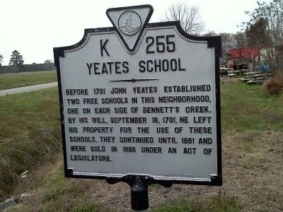
Photographed by James Thomson
1. Yeates School Marker
Erected 1960 by Virginia State Library. (Marker Number K-255.)
Topics and series. This historical marker is listed in these topic lists: Education • Patriots & Patriotism. In addition, it is included in the Virginia Department of Historic Resources (DHR) series list. A significant historical month for this entry is September 1781.
Location. 36° 49.426′ N, 76° 30.029′ W. Marker is in Suffolk, Virginia. It is in Driver. It is at the intersection of Nansemond Parkway (Virginia Route 337) and Kings Highway ( Route 125), on the right when traveling west on Nansemond Parkway. Touch for map. Marker is at or near this postal address: 3102 Kings Highway, Suffolk VA 23435, United States of America. Touch for directions.

Regionally, this marker is in Virginia’s Hampton Roads, specifically in Coastal Virginia, and in the Hampton Roads Metropolitan Area. It
this page online
Other nearby markers. At least 8 other markers are within 2 miles of this marker, measured as the crow flies: Sleepy Hole Ferry (here, next to this marker); Bennett's Home (approx. 0.2 miles away); Glebe Church (approx. ¼ mile away); Hargrove's Tavern (approx. ¼ mile away); a different marker also named Glebe Church (approx. ¼ mile away); James Bowser, Revolutionary Soldier (approx. 0.3 miles away); Florence Graded School (approx. half a mile away); James Bowser Plantation (approx. 1½ miles away). Touch for a list and map of all markers in Suffolk.
Another marker is no longer nearby. Florence Graded School (was approx. half a mile away but has been replaced with another marker now near
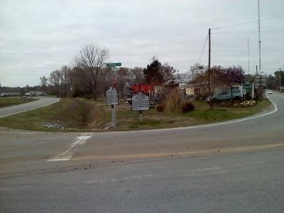
Photographed by James Thomson
2. Yeates School Marker
Credits. This page was last revised on February 1, 2023. It was originally submitted on March 23, 2011, by James Thomson of Chesapeake, United States. This page has been viewed 1,717 times since then and 102 times this year. Photos: 1, 2. submitted on March 23, 2011, by James Thomson of Chesapeake, United States. • Bill Pfingsten was the editor who published this page.
