Near Fredericksburg in Spotsylvania County, Virginia — The American South (Mid-Atlantic)
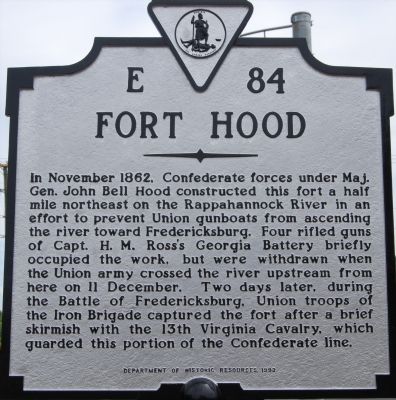
Fort Hood
Erected 1993 by Department of Historic Resources. (Marker Number E-84.)
Topics and series. This historical marker is listed in this topic list: War, US Civil. In addition, it is included in the Virginia Department of Historic Resources (DHR) series list. A significant historical month for this entry is November 1862.
Location. 38° 15.167′ N, 77° 25.577′ W. Marker is near Fredericksburg, Virginia, in Spotsylvania County. Marker is at the intersection of Benchmark Road (County Route 608) and Tidewater Trail (Virginia Route 2), on the right when traveling north on Benchmark Road. Touch for map. Marker is at or near this postal address: 10748 Tidewater Trail, Fredericksburg VA 22408, United States of America. Touch for directions.
Other nearby markers. At least 8 other markers are within walking distance of this marker. The Gallant Pelham (here, next to this marker); Stuart and Pelham (here, next to this marker); The Battle of Fredericksburg (a few steps from this marker); a different marker also named The Gallant Pelham (a few steps from this marker); Fredericksburg Campaign (approx. 0.6 miles away); Dead Horse Hill (approx. 0.6 miles away); a different marker also named Fredericksburg Campaign (approx. 0.6 miles away); Jackson Holds Prospect Hill (approx. 0.6 miles away). Touch for a list and map of all markers in Fredericksburg.
Related markers. Click here for a list of markers that are related to this marker.
Credits. This page was last revised on August 6, 2023. It was originally submitted on July 13, 2007, by Dawn Bowen of Fredericksburg, Virginia. This page has been viewed 1,830 times since then and 63 times this year. Last updated on December 11, 2007, by Christopher Light of Valparaiso, Indiana. Photos: 1, 2. submitted on July 13, 2007, by Dawn Bowen of Fredericksburg, Virginia. • Craig Swain was the editor who published this page.

