Near Avery in Erie County, Ohio — The American Midwest (Great Lakes)
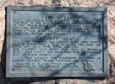
Camp Avery
⎯⎯⎯
County Seat
Photographed by Dale K. Benington, April 21, 2011
1. Camp Avery / County Seat Marker
1818 County seat moved from here to Norwalk.
1838 Erie County was established from the northern part of Huron County.
This locality was frequented by tribes of Indians: Ottowas, Miamis, Chippewas and Senecas.
Erected 1930 by Martha Pitkin Chapter, Daughters of the American Revolution.
Topics and series. This historical marker is listed in these topic lists: Settlements & Settlers • War of 1812. In addition, it is included in the Daughters of the American Revolution (DAR) series list. A significant historical year for this entry is 1811.
Location. 41° 19.841′ N, 82° 34.498′ W. Marker is near Avery, Ohio, in Erie County. It is on River Road 0.3 miles south of East Mason
this page online

Regionally, this marker is on Ohio’s Lake Erie Shore and in the Western Reserve. It is also in the American Midwest and in the Corn Belt. Globally, it is in North America, on the Great Lakes, in the Western Hemisphere, in the Western World, and in the Anglosphere. Historically, it finds itself in what was once the Haudenosaunee (Iroquois) Confederacy, the territory of the Mississippian Culture, and the Northwest Territory.
Other nearby markers. At least 8 other markers are within 3 miles of this marker, measured as the crow flies: Milan Township Veterans Memorial (approx. 2.2 miles away); Historical Sites Milan Canal Era (approx. 2.4 miles away); Milan (approx. 2½ miles away); Milan's Hogback
Photographed by Dale K. Benington, April 21, 2011
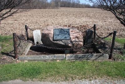
2. Camp Avery / County Seat Marker
View of the Camp Avery / County Seat marker with a veteran's grave on either side of the historical marker.
More about this marker. According to the website provided by the Erie County Commissioners, "When the War of 1812 broke out there was a small militia unit stationed at Fort Avery, a stockade on the Huron River north of Milan. These troops and local civilians fought a contingent of Indians on the Marblehead Peninsula in September 1812. This was the first battle of that war in Ohio and one of the few skirmishes in the state."
Related markers. Click here for a list of markers that are related to this marker. To better understand the relationship, study each marker in the order shown.
Photographed by Dale K. Benington, April 21, 2011
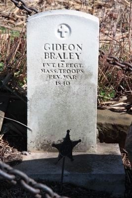
3. Camp Avery / County Seat Marker
View of the gravestone of Gideon Braley, a Revolutionary War veteran, whose gravestone is on the left side of the Camp Avery / County Seat marker.
Photographed by Dale K. Benington, April 21, 2011
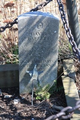
4. Camp Avery / County Seat Marker
View of the gravestone of David Barrett, a War of 1812 veteran, whose gravestone is on the right side of the Camp Avery / County Seat marker.
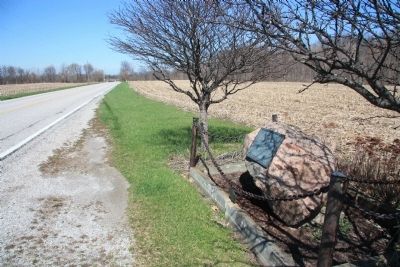
Photographed by Dale K. Benington, April 21, 2011
5. Camp Avery / County Seat Marker
View looking north along River Road, of the historical marker.
Credits. This page was last revised on October 2, 2025. It was originally submitted on April 22, 2011, by Dale K. Benington of Toledo, Ohio. This page has been viewed 2,484 times since then and 103 times this year. Photos: 1, 2, 3, 4, 5. submitted on April 24, 2011, by Dale K. Benington of Toledo, Ohio.
