
Downtown Kansas City in Jackson County, Missouri — The American Midwest (Upper Plains)
Union Prison Collapse
Photographed by William Fischer, Jr., December 19, 2010
1. Union Prison Collapse Marker
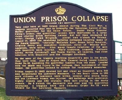
Very near here at 1425 Grand Avenue during The Civil War, a tragedy occurred that was to intensify the ferocious hatred of the Border guerrillas for the Union forces. Under Union General Ewing's orders, the guerrillas' women were imprisoned in a large three-storied brick building owned, but not then occupied by artist, George Caleb Bingham. About two o'clock on Friday, August 14, 1863 the weakened building collapsed injuring many of the female inmates. "Christie" McCorkle Kerr, Susan Selvy Vandiver, Arminia Selvy and Josephine Anderson, sister of "Bloody Bill" Anderson, were killed. Also many female relatives of the men with Quantrill were injured. Mary Anderson, Armenia Whitsett Gilvey, Mollie Grindstaff, and Nanie Harris, all injured, had close relatives with Quantrill and the Younger brothers.
On the news of the tragedy reaching Quantrill's men in the brush, they were wild. Also on August 18th, General Ewing issued General Order No.10, banishing the guerrillas' families from the state. Coupled with the death and injury in the collapse, then banishment of their women, the guerrillas seemed to scream for retaliatory measures.
Friday,
this page online
Erected by Native Sons and Daughters of Greater Kansas City.
Topics and series. This historical marker is listed in these topic lists: Fraternal or Sororal Organizations • Settlements & Settlers • War, US Civil. In addition, it is included in the Kansas City - Native Sons and Daughters of Greater Kansas City series list. A significant historical year for this entry is 1425.
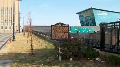
Location. 39° 5.774′ N, 94° 34.853′ W. Marker is in Kansas City, Missouri, in Jackson County. It is in Downtown Kansas City. It is at the intersection of Grand Boulevard and Truman Road North Drive, on the right when traveling north on Grand Boulevard. Marker is south across Truman Road from
Photographed by William Fischer, Jr., December 19, 2010
2. Union Prison Collapse Marker
Looking east

Regionally, this marker is in the American Midwest, in the Lewis & Clark Corridor, in the Corn Belt, and on the Santa Fe Trail Corridor. Globally, it is in North America, the Western Hemisphere, the Western World, and the Anglosphere. Historically, it finds itself in what was once the territory of the Mississippian Culture, the Louisiana Purchase, and the Antebellum South.
Other nearby markers. At least 8 other markers are within walking distance of this marker: Kansas City Metropolitan Crime Commission (approx. 0.2 miles away); William Rockhill Nelson (approx. ¼ mile away); The Greater Kansas City Restaurant Association (approx. 0.3 miles away); Kansas City Municipal Auditorium (approx. 0.3 miles away); Aladdin Hotel (approx. 0.3 miles away); St. Mary's Church (approx. 0.3 miles away); Convention Center (approx. 0.4 miles away); Phoenix Society for Individual Freedom / North American Conference of Homophile Organizations (approx. 0.4 miles away). Touch for a list and map of all markers in Kansas City.
Also see . . .
1. Collapse of the Military Prison in 1918 Kansas and Kansans. Kansas GenWeb entry (Submitted on April 30, 2011, by William Fischer, Jr. of Reynoldsburg, Ohio.)
2. Quantrill’s Raid on Lawrence. Civil War on the Wester Border website entry (Submitted on August 5, 2024, by Larry Gertner of New York, New York.)
3. Ladd's Description of the Lawrence Massacre. Kansas Historical Society website entry (Submitted on April 30, 2011, by William Fischer, Jr. of Reynoldsburg, Ohio.)
Credits. This page was last revised on August 5, 2024. It was originally submitted on April 29, 2011, by William Fischer, Jr. of Reynoldsburg, Ohio. This page has been viewed 4,152 times since then and 199 times this year. Photos: 1, 2. submitted on April 30, 2011, by William Fischer, Jr. of Reynoldsburg, Ohio.
