Victorian Village in Columbus in Franklin County, Ohio — The American Midwest (Great Lakes)
Flytown
Inscription.
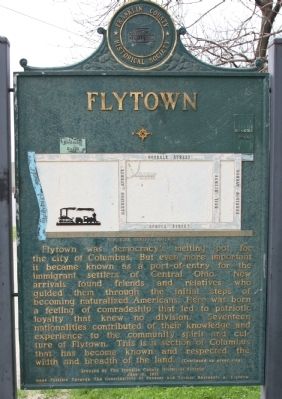
Flytown was democracy’s melting pot for
the city of Columbus. But even more important
it became known as a port-of-entry for the
immigrant settlers of Central Ohio. New
arrivals found friends and relatives who
guided them through the initial steps of
becoming naturalized Americans. Here was born
a feeling of comradeship that led to patriotic
loyalty that knew no division. Seventeen
nationalities contributed of their knowledge and experience to the community spirit and culture of Flytown. This is a section of Columbus that has become known and respected the width and breadth of the land.
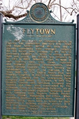
In 1865 the district of Columbus known as Flytown was subdivided into city lots. Brick and frame houses dotted the area and a friendly community soon emerged. Industry did not locate here because of the lack of necessary facilities. In order to obtain water, light and power, the district was annexed to the city in 1880. Industry began to move in since building sites were cheap, railroads and highways provided transportation, and water became available. An iron foundry was established in 1870 to be followed a few years later by The United States Pipe and Foundry Company. In 1900 the Columbus Forge and Iron Company and The Commercial Paste Company built plants in Flytown. In 1901 The Franklin Lumber and Furniture Company was founded and shops were constructed by The Columbus, Piqua and Indianapolis Railroad. All of these plants and others employed immigrant workmen—Germans, Irish, Negroes, Italians, Swedes, Jewish, Greeks, Hungarians and others. When Rosenthal Brothers – Wool-Pullers, located on Spruce Street, there were no houses for their employees. A building marathon ensued. It is said that houses literally “flew-up” overnight—thus the name “Flytown” was coined.
Erected 1961 by The Franklin County Historical Society, June 16, 1961. Made possible through the contributions of present and former residents for Flytown.
Topics. This historical marker is listed in these topic lists: Industry & Commerce • Political Subdivisions. A significant historical year for this entry is 1865.
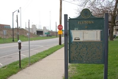
Location. 39° 58.433′ N, 83° 0.528′ W. Marker is in Columbus, Ohio, in Franklin County. It is in Victorian Village. Marker is on West Goodale Street west of Park Street. It is on the southern edge of Goodale Park, almost at Dennison Avenue. Touch for map. Marker is in this post office area: Columbus OH 43215, United States of America. Touch for directions.
Other nearby markers. At least 8 other markers are within walking distance of this marker. James S. Tyler / Tyler Family Legacy (approx. 0.2 miles away); Lincoln Goodale (approx. 0.2 miles away); Tod Barracks, 1863 (approx. 0.3 miles away); Arnold Schwarzenegger (approx. 0.4 miles away); Columbus' First Professional Game (approx. 0.4 miles away); The Columbus Buckeyes (approx. 0.4 miles away); The Western League (approx. 0.4 miles away); The Negro Leagues in Columbus (approx. 0.4 miles away). Touch for a list and map of all markers in Columbus.
Also see . . . Flytown Wikipedia Entry. “Decline. The neighborhood, considered lower-class, was hit hard by the Great Depression, beginning a cycle of decline. By 1953, the Columbus Redevelopment Authority declared the area blighted, and a bond was passed to raize much of the neighborhood. The Goodale Expressway, which would eventually become I-670, began construction, resulting in further destruction of the neighborhood as it cut through its heart. ... Renewal. The city invested $6 million in what they called Thurber Village in Flytown’s place, and high-rise apartment complexes sprang up, including Thurber Towers and Westminster Terrace. ... Present. Today the neighborhood is rarely referred to as Flytown as neighboring areas have incorporated much of what was Flytown as part

Photographed By J. J. Prats, April 15, 2011
3. Map on Marker
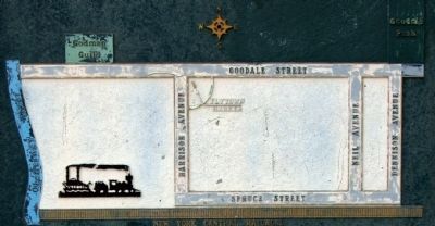
The “you are here” arrow is no longer correct. The marker was moved two blocks east in 2000 when Interstate 670 was widened. It was on the southeast corner of Goodale Street and Harrison Avenue. Harrison Avenue no longer exists. Now it is on the north side of Goodale just east of Dennison Avenue. This map is bounded on the left by the Olentangy River, on the bottom by the New York Central Railroad, Dennison Avenue on the right and Goodale Street on the top.
Credits. This page was last revised on February 3, 2023. It was originally submitted on May 7, 2011, by J. J. Prats of Powell, Ohio. This page has been viewed 1,080 times since then and 42 times this year. Photos: 1, 2, 3, 4. submitted on May 7, 2011, by J. J. Prats of Powell, Ohio.


