Knoxville in Knox County, Tennessee — The American South (East South Central)
Fort Dickerson 1863–64
The forts surrounding Knoxville were named for Federal officers who died during the Knoxville Campaign. Ft. Dickerson was named in honor of Capt. Jonathan C. Dickerson of the 112th Illinois Mounted Infantry, who was killed in action at Cleveland, TN.
Ft. Dickerson, rising 200 feet above Knoxville and the Holston (now Tennessee) River, was flanked on the west by Ft. Higley and on the east by Ft. Stanley. These forts were designed to protect Knoxville from the south and guard the roads from Maryville and Sevierville.
The fort came under direct attack only once during the early stages of Confederate Gen. James Longstreet’s Campaign to capture Knoxville. Confederate Gen. “Fightin’ Joe” Wheeler was ordered to take the heights opposite Knoxville and, with 4,500 cavalry, surprised the Federal cavalry outpost at Maryville on the morning of November 14, 1863. The sound of the attack alerted Gen. William P. Sanders’ Federal Cavalry Division of 1,500 men who were headquartered a few miles away at Rockford. Although vastly outnumbered, Sanders stubbornly fought a series of delaying actions that enabled the Federals to dig rudimentary earthworks and man the fort with both artillery and infantry. The surprised Confederates found not only cavalry, but also infantry and artillery waiting at Ft. Dickerson. After exchanging artillery and small arms fire Wheeler was convinced that the heights could not be easily taken. Due to the formidable heights, steep slopes and unexpected firepower, Wheeler decided that further attacks would be too costly in both manpower and time. The Confederates retreated southward, rejoining Longstreet’s force after the Battle of Campbell’s Station on November 16th.
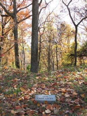
Ft. Dickerson has survived for over 140 years, but it is now a mere shell of the 1864 fort. The parapet which once sheltered the soldiers with its six foot walls is now barely knee
high, gun embrasures are marked by mere hints of depressions in the walls; the collapsed powder magazine is a shallow depression and the dry ditch around the fort is now partially filled with the earth washed down from the parapet. Abuse, overgrowth and erosion from thee wind and rain have ravaged its strong design, but Fort Dickerson still stands as an enduring reminder of East Tennessee's role in the Civil War.
Topics. This historical marker is listed in this topic list: War, US Civil. A significant historical month for this entry is February 1864.
Location. 35° 56.919′ N, 83° 54.977′ W. Marker is in Knoxville, Tennessee, in Knox County. Marker is on Fort Dickerson Road west of Chapman Hignway SW, on the left when traveling north. Touch for map. Marker is in this post office area: Knoxville TN 37920, United States of America. Touch for directions.
Other nearby markers. At least 8 other markers are within walking distance of this marker. Civil War Knoxville (here, next to this marker); The 1863 Siege of Knoxville (here, next to this marker); Fort Dickerson (here, next to this marker); a different marker also named Fort Dickerson (within shouting distance of this marker); a different marker also named Fort Dickerson (within shouting distance of this marker); Forts Dickerson and Stanley (approx. 0.2 miles away); Back Door to Knoxville (approx. 0.3 miles away); a different marker also named Fort Dickerson (approx. 0.3 miles away). Touch for a list and map of all markers in Knoxville.
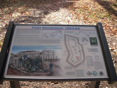
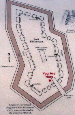
More about this marker. On the upper right of the marker is a “Cut-Away—Showing the profile of the earthworks including the interior, the infantry firing step, the parapet, the dry ditch and the counter scarp.” A large “Engineer’s overhead diagram of Fort Dickerson, which was constructed in the winter of 1863–64,” dominates the right side of the marker. Drawings of the “Exterior View of the Cannon Embrasure,” the “Infantry Parapet,” and the “Inside view of Entrance Gate” surround the overhead diagram.
On the lower right are two drawings, the “Ground Plan” and a “Cross Section” of the “Powder Magazine—Built to protect powder and ammunition, the magazine was constructed of logs below ground level with a layer of earth over the roof to protect the powder. The logs eventually decayed and the roof collapsed, leaving the depression in the center of the fort.”
A large color illustration of cannoneers loading a cannon at an embrasure dominates the lower left of the marker, a topological map showing the locations of Forts Stanley, Dickerson and Higley in relation to each other and the Holston (now Tennessee) River is at the top center, and a small photograph of a “Replica 3-inch Ordnance Rifle in Fort Dickerson” round out the illustrations.
Regarding Fort Dickerson 1863–64. This is one of several markers interpreting Fort Dickerson and Civil War activity around Knoxville. See the Fort Dickerson Virtual Tour by Markers linked below.
Credits. This page was last revised on September 22, 2020. It was originally submitted on November 30, 2007, by Laura Troy of Burke, Virginia. This page has been viewed 1,991 times since then and 34 times this year. Photos: 1, 2, 3, 4. submitted on November 30, 2007, by Laura Troy of Burke, Virginia. • Craig Swain was the editor who published this page.


