Near Austinville in Wythe County, Virginia — The American South (Mid-Atlantic)
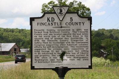
Fincastle County
Erected 2002 by Department of Historic Resources. (Marker Number KD-5.)
Topics and series. This historical marker is listed in these topic lists: Political Subdivisions • War, US Revolutionary. In addition, it is included in the Virginia Department of Historic Resources (DHR) series list. A significant historical year for this entry is 1772.
Location. 36° 53.128′ N, 80° 54.175′ W. Marker is near Austinville, Virginia, in Wythe County. Marker is on Fort Chiswell Road (U.S. 520) just south of Austinville Road (County Route 619), on the left when traveling south. Touch for map . Marker is in this post office area: Austinville VA 24312, United States of America. Touch for directions.
Other nearby markers. At least 8 other markers are within 3 miles of this marker, measured as the crow flies. New River (approx. 1˝ miles away); a different marker also named The New River (approx. 1.7 miles away); Jackson’s Ferry and Shot Tower (approx. 2 miles away); Shot Tower Historical State Park (approx. 2.1 miles away); Shot Tower at Jackson's Ferry (approx. 2.1 miles away); History of the Shot Tower (approx. 2.1 miles away); Jackson's Ferry (approx. 2.1 miles away); River Crossing Old & New (approx. 2.2 miles away). Touch for a list and map of all markers in Austinville.
More about this marker. This marker replaces a 1932 marker with the same number titled “Seat of Fincastle County” that read “Three miles southwest, on New River, was the seat of Fincastle County, which from 1772 to 1776 embraced Southwestern Virginia, including Kentucky. There are the ancient lead mines, visited and described by Thomas Jefferson.”
Also see . . . Wikipedia Entry for Fincastle County, Virginia. “Fincastle County was created in 1772 from Botetourt County, whose boundaries extended all the way to the Mississippi River. Fincastle County was abolished in 1776, and divided into three new counties - Montgomery Country, Washington County, and Kentucky County (which later became the Commonwealth of Kentucky).
“The name remains on Virginia maps with the town of Fincastle, the county seat of the original Botetourt County. The town was possibly named after the English home of Governor Norborne Berkeley, 4th Baron Botetourt. Lord Botetourt was a very popular governor of the Virginia colony, and died just before the tensions of the impending American Revolution made the job much more difficult.
“John Murray, 4th Earl of Dunmore and Viscount of Fincastle, succeeded Lord Botetourt. Fincastle County may have been named in his honor, or for his son Lord Fincastle. If so, the decision to change the name in 1776 is very logical. At that time, Lord Dunmore was leading the military opposition to the "rebels" in Virginia, and had already issued the Emancipation Proclamation offering to free any slave who fled their Virginia masters and joined the royal British forces.” (Submitted on June 12, 2011.)
Credits. This page was last revised on June 16, 2016. It was originally submitted on June 12, 2011, by J. J. Prats of Powell, Ohio. This page has been viewed 1,107 times since then and 56 times this year. Photos: 1, 2. submitted on June 12, 2011, by J. J. Prats of Powell, Ohio.

