Weston in Platte County, Missouri — The American Midwest (Upper Plains)
Presbyterian Church
1844
| — | Weston Historic District | — |
Photographed by William Fischer, Jr., May 28, 2011
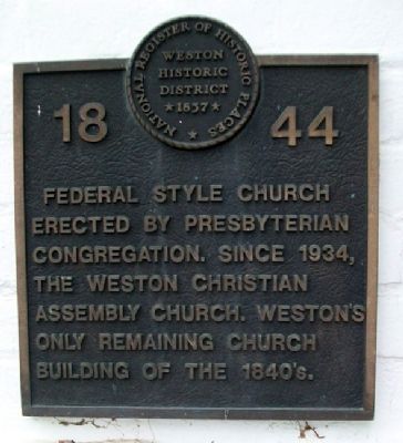
1. Presbyterian Church Marker
National Register of Historic Places Nomination Form
Click for more information.
Click for more information.
Federal style church erected by Presbyterian congregation. Since 1934, the Weston Christian Assembly Church. Weston's only remaining church building of the 1840's.
Topics. This historical marker is listed in these topic lists: Architecture • Religion & Religious Structures. A significant historical year for this entry is 1934.
Location. 39° 24.745′ N, 94° 54.237′ W. Marker is in Weston, Missouri, in Platte County. It is at the intersection of Washington Street and Thomas Street, on the left when traveling north on Washington Street. Touch for map. Marker is at or near this postal address: 501 Washington Street, Weston MO 64098, United States of America. Touch for directions.

Regionally, this marker is in Greater Kansas City. It is also in the American Midwest, in the Lewis & Clark Corridor, and in the Corn Belt. Globally, it is in North America, the Western Hemisphere, the Western World, and the Anglosphere. Historically, it finds itself in what was once the territory of the Mississippian Culture, the Louisiana Purchase, and the Antebellum South.
Other nearby markers. At least 8 other markers are within
this page online
Also see . . . Weston Historic Buildings. Visit Weston website entry (Submitted on July 11, 2011, by William Fischer, Jr. of Reynoldsburg, Ohio.)
Photographed by William Fischer, Jr., May 28, 2011
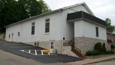
2. Former Presbyterian Church and Marker
Credits. This page was last revised on July 6, 2022. It was originally submitted on July 11, 2011, by William Fischer, Jr. of Reynoldsburg, Ohio. This page has been viewed 631 times since then and 22 times this year. Photos: 1. submitted on July 11, 2011, by William Fischer, Jr. of Reynoldsburg, Ohio. 2. submitted on July 12, 2011, by William Fischer, Jr. of Reynoldsburg, Ohio.
