Near Deep Creek Community in Spokane County, Washington — The American West (Northwest)
Camp Washington
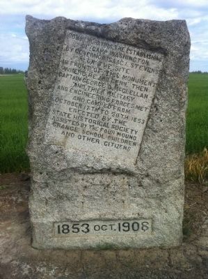
Photographed by Brian A. Sayrs, July 11, 2011
1. Camp Washington Marker
Erected 1908 by State Historical Society assisted by the Four Mound Grange, school children, and other citizens.
Topics. This historical marker is listed in these topic lists: Exploration • Notable Places. A significant historical month for this entry is October 1902.
Location. 47° 44.697′ N, 117° 44.439′ W. Marker is near Deep Creek Community, Washington, in Spokane County. It is on Coulee Hite Road, on the right when traveling west. Between N. Wood & N. Gray Roads. Touch for map. Marker is in this post office area: Reardan WA 99029, United States of America. Touch for directions.

Regionally, this marker is in Greater Spokane. It is also in the American Mountain West and in the Lewis & Clark Corridor. Globally, it is in North America, on the Pacific Rim, in the Western Hemisphere, in the Western World, and in the Anglosphere.
Other nearby markers. At
this page online
Credits. This page was last revised on June 16, 2016. It was originally submitted on July 31, 2011, by Brian A. Sayrs of Spokane, Washington. This page has been viewed 1,913 times since then and 63 times this year. Photo 1. submitted on July 31, 2011, by Brian A. Sayrs of Spokane, Washington. • Bill Pfingsten was the editor who published this page.
