Near Avery in Shoshone County, Idaho — The American West (Mountains)
Bridging the Gaps
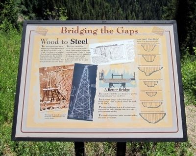
Wood to Steel
The Milwaukee Road built temporary wood trestles at all but Kelly Creek and Clear Creek. Fire danger prompted the railroad to immediately begin replacing the wooden structures with earth-filled embankments or building steel bridges inside and over them.
The Milwaukee used a relatively new steel design—“deck girder bridges” with solid concrete floors. Large “I” beams on top of steel towers supported “U” shaped concrete tubs. These held a layer of rock ballast on which the ties and rails set.
(sidebar)
A Better Bridge
The initial cost of the new design was greater, but maintenance was much less.
Local section gangs, rather than special bridge gangs, could regularly attend the track on the trestle.
The ballasted floors practically eliminated impact stress and vibration from the trains going over the trestles.
The steel bridges were safer, smoother riding and more permanent.
How Long? How High?
Route of the Hiawatha Trestles
Small Creek (trestle #216) – 515 long, 120 high
Barnes Creek (trestle #218) – 507 long, 117 high
Kelly Creek (trestle #220) – 850 long, 230 high
Turkey Creek (trestle #224) – 494 long, 146 high
Russell, “No Name”(trestle #226) – 281 long, 90 high
Bear Creek (trestle #228) – 570 long, 155 high
Topics. This historical marker is listed in these topic lists: Bridges & Viaducts • Railroads & Streetcars.
Location. 47° 21.112′ N, 115° 38.238′ W. Marker is near Avery, Idaho, in Shoshone County. Marker can be reached from Cliff Creek Road (Federal Road 506) 1.8 miles north of Loop Creek Road (Federal Road 326). Located along the Route of the Hiawatha Trail. Touch for map. Marker is in this post office area: Avery ID 83802, United States of America. Touch for directions.
Other nearby markers. At least 8 other markers are within walking distance of this marker. No Ones Fault (approx. 0.2 miles away); Little in Name Only (approx. 0.3 miles away); The 1910 Fires (approx. 0.3 miles away); Section Gangs (approx. 0.4 miles away); The Big Blowup (approx. half a mile away); The Olympian Hiawatha (approx. 0.6 miles away); Olympian Luxury (approx. 0.6 miles away); The Traveler (approx. 0.8 miles away). Touch for a list and map of all markers in Avery.
More about this marker. On the left is a photo with the caption, "The blueprint shows how a steel trestle was built within the old wooden bridge." Photograph courtesy of Montana Historical Society
On the top right is a diagram of "Plans for changing from wooden to steel trestles."
Also see . . . Route of the Hiawatha Rail Trail. (Submitted on August 4, 2011, by Bernard Fisher of Richmond, Virginia.)
Credits. This page was last revised on June 16, 2016. It was originally submitted on August 4, 2011, by Bernard Fisher of Richmond, Virginia. This page has been viewed 682 times since then and 10 times this year. Photos: 1, 2. submitted on August 4, 2011, by Bernard Fisher of Richmond, Virginia.

