Belle Fourche in Butte County, South Dakota — The American Midwest (Upper Plains)
Lasting Legacy
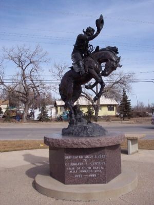
March 6, 2006
1. Lasting Legacy Marker
Bronze sculpture by Tony R. Chytka stands approximately 8 1/2 feet tall on a three foot tall concrete base.
to
Celebrate a Century
State of South Dakota
Belle Fourche area
1889-1989
Erected 1989 by City of Belle Fourche.
Topics. This historical marker is listed in these topic lists: Notable Events • Settlements & Settlers. A significant historical date for this entry is July 3, 1861.
Location. 44° 39.75′ N, 103° 51.29′ W. Marker is in Belle Fourche, South Dakota, in Butte County. It is at the intersection of 5th Avenue (U.S. 85) and National St. on 5th Avenue. Touch for map. Marker is in this post office area: Belle Fourche SD 57717, United States of America. Touch for directions.

Regionally, this marker is in West River. It is also in the American Black Hills, in the Lewis & Clark Corridor, on the prairies, and on the Northern Plains. Globally, it is in North America, the Western Hemisphere, the Western World, and the Anglosphere. Historically, it finds itself in what was once Rupert’s Land and also the Louisiana Purchase.
Other nearby markers. At least 8 other markers are within walking distance of this marker: Tri-State Area Veterans Memorial (approx. 0.4 miles away); Butte County Jail
this page online
Regarding Lasting Legacy. The town of Belle Fourche was founded in 1891. The town was started when the railroad bypassed Minnesela, then the trade center and county seat. They built shipping pens on Middle Creek west of town and a depot at the old Belle Fourche River Crossing.
No one can dispute the name that early French explorers and trappers tagged onto the bustling little city of Belle Fourche. At a junction about a mile east of the center of town, the swift, turbulent waters of Redwater Creek empty into the placid, slow moving Belle Fourche River. It was because of this junction that the founders named it aptly, Belle Fourche, meaning Beautiful Forks in the French language
Early in the century, settlers realized that the broad valley extending northeast of Belle Fourche would be ideal for raising small grain and farming if water was available. Belle Fourche became a trade center and fun spot for cow punchers, sheep ranchers and farmers in the vast area. The Northwestern railroad was quick to recognize the potential of the town as a shipping point and soon built their line from Whitewood to Belle Fourche and on to Newell. At the turn of the century the city was the largest livestock shipping point in the entire West.
Credits. This page was last revised on June 16, 2016. It was originally submitted on January 7, 2008, by Kevin W. of Stafford, Virginia. This page has been viewed 2,103 times since then and 32 times this year. Photo 1. submitted on January 7, 2008, by Kevin W. of Stafford, Virginia.
