New Franklin in Howard County, Missouri — The American Midwest (Upper Plains)
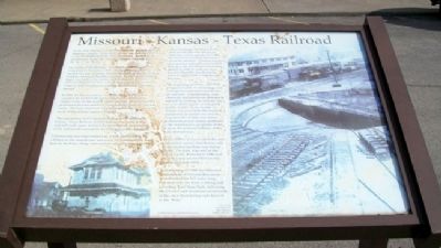
Missouri - Kansas - Texas Railroad
As the first railroad to enter Texas from the North in 1872, the Missouri-Kansas-Texas Railroad Co. was an influential factor in the development of the Great Southwest. Soon after its construction began, the railroad became commonly known as the "K-T" or "Katy".
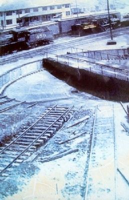
The tracks of the Missouri-Kansas-Texas Railroad were completed to Franklin in 1893. A roundhouse and shops were located in a low, swampy, bottom land just southwest of New Franklin, known as Franklin Junction. In 1895, a two-story depot was built at this section and served as a division terminal office for twelve years. It was moved to a location closer to New Franklin on a string of flatbed cars and later burned.
In 1906, the Businessmen's Association of New Franklin acquired the land from the railroad to build a reservoir to supply water for the mighty steam engines. This secured the permanent division point for location at the Franklin Junction yards. The Katy Reservoir, as it became known, lies just to the north of the railroad yards at Franklin.
The expenditure of 15.5 million dollars by the Missouri-Kansas-Texas Railway in 1923 for improvements to the railroad yards, again assured the growth and continuation of the railroad division point location in Franklin Junction.
Construction of a forty-room hotel, a new powerhouse, an addition to the roundhouse and a new 90-foot turntable, were built by the Katy, along with machine shops, a new depot and office buildings. An immense oil tank 30 feet high and 114 feet in diameter with a capacity of 55,000 barrels of oil was erected to store oil for locomotives. Franklin became an important railroad center in 1923. Katy payroll was nearly half-million dollars in 1930-31, with the New Franklin-Franklin area becoming the second largest of the company's in the state.
The beginning of WWII, 1939-1945, produced floods of rail tonnage and consequent years of prosperity for all railroads. Unfortunately, coal, chemicals and petroleum derivatives needed for treating the railroad ties were in short supply, as was good quality timber. Some twenty to twenty-five years later the wartime installation of inferior ties and the long stretches of fifty and ninety pound rails posed serious problems in the maintenance programs of the Katy as the postwar fortunes of the Katy deteriorated.
By the 1980's, it was evident the once undaunted, proud, thundering rails of the pioneering Katy was losing steam. The Katy was sold to the Union Pacific in 1986 and all of her rails across Missouri lay abandoned and silent.
In the spring of 1990, the Missouri Department of Natural Resources transformed the 225 miles long rail beds into the Katy walking and bicycling Trail State Park, following the diverse and beautiful countryside of the once thundering rails known as the "Katy."
Erected by South Howard County Historical Society.
Topics. This historical marker is listed in these topic lists: Industry & Commerce • Railroads & Streetcars. A significant historical year for this entry is 1872.
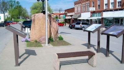
Location. 39° 1.035′ N, 92° 44.184′ W. Marker is in New Franklin, Missouri, in Howard County. Marker is on Broadway, in the median. Touch for map. Marker is at or near this postal address: 125 East Broadway, New Franklin MO 65274, United States of America. Touch for directions.
Other nearby markers. At least 8 other markers are within walking distance of this marker. "Missouri Waltz" (here, next to this marker); Franklin and New Franklin (here, next to this marker); End of Boone's Lick Trail (here, next to this marker); City of Trails (here, next to this marker); Franklin (here, next to this marker); Santa Fe Trail Marker (a few steps from this marker); KATY Caboose #127 (within shouting distance of this marker); Santa Fe Trail (approx. 0.3 miles away). Touch for a list and map of all markers in New Franklin.
More about this marker. Marker is deteriorating.
Related marker. Click here for another marker that is related to this marker.
Also see . . .
1. New Franklin, Missouri. (Submitted on August 26, 2011, by William Fischer, Jr. of Scranton, Pennsylvania.)
2. Katy Railroad Historical Society. (Submitted on August 26, 2011, by William Fischer, Jr. of Scranton, Pennsylvania.)
3. MKT Railroad History Along the Katy Trail. (Submitted on August 26, 2011, by William Fischer, Jr. of Scranton, Pennsylvania.)
4. Katy Trail State Park. (Submitted on August 26, 2011, by William Fischer, Jr. of Scranton, Pennsylvania.)
Credits. This page was last revised on June 16, 2016. It was originally submitted on August 25, 2011, by William Fischer, Jr. of Scranton, Pennsylvania. This page has been viewed 779 times since then and 13 times this year. Photos: 1, 2, 3. submitted on August 26, 2011, by William Fischer, Jr. of Scranton, Pennsylvania.


