The Lewis and Clark Expedition Across Missouri
William Clark, June 25, 1804.
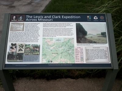
The Lewis and Clark Expedition passed this location on June 25, 1804. That morning a heavy fog delayed the departure of the expedition from the campsite of the previous day, which was near present-day Atherton. The river was running high but was just beginning to drop. At three miles, the party passed some hills on the south (left) side of the river that were banded with seams of coal. After passing a creek that Capt. William Clark called “Chabonea” Creek (known as Lazy Branch today), the expedition began to encounter some “hard water” along with large logs floating in the river, and river banks that were caving in. The Flotilla then passed “Labeenie” or “Bennet’s Creek (probably today’s Mill Creek), and Clark noted that in the stretch of the river “…The Prairies Come within a Short distance of the river on each Side which Contains Plumbs Rasberries & vast quantities of wild (crab) apples, and wild flowers.” He also noted the great numbers of deer feeding along the banks. Indeed, for the last two days, the Corps of Discovery had been passing through
what seemed to be a veritable paradise of plants and animals. As the men of the Lewis and Clark Expedition moved beyond the expanding settlements, they encountered a vast and fertile landscape, lush with vegetation and teeming with wildlife.That afternoon, the expedition encountered hard water going around the heads of some small islands and as they negotiated around a sharp bend later known as Liberty Bend. Liberty Sports Complex is located not far from this old bend in the river, which was later cut off and abandoned by the Missouri River. Sgt. John Ordway mentioned in his journal handsome high prairies on the south side of the river in the vicinity of this bend and also noted that beyond these prairies a range of highlands appeared next to the river. That evening the expedition camped on an island near present-day Sugar Creek.
As the Lewis and Clark Expedition passed through this region, the journal keepers described a lush environment abundant with crap apples and raspberries and large herds of deer and many bears. John James Audubon paintings of deer and bears used with permission, State Historical Society of Missouri, Columbia; crab apple engraving, New York Botanical Society; raspberry engraving, Missouri Botanical Society.
The Lewis and Clark Expedition interpretive sign was produced in cooperation with the City of Liberty, Mo.
Map prepared by
In 1832, George Catlin painted this scene of alluvial banks falling into the Missouri River. The Lewis and Clark Expedition experienced collapsing river banks on June 25, 1804, and on many other occasions in their daily battle against the treacherous and swift currents of the Missouri River. Smithsonian American Art Museum, Gift of Mrs. Joseph Harrison, Jr.
Wildlife Paradise
One gauge of the lushness of the land the Lewis and Clark Expedition was passing through on the lower Missouri River was the number of deer, bear and other animals killed by the hunters to supply the men with fresh meat. During the month of June, the expedition hunters killed 77 deer, 14 bears, one wolf, two turkeys, several geese and a few rabbits. Eighteen of the deer were killed in the four days between June 23 and June 26 when the expedition was passing through the fertile woodland and prairie environments of present-day Jackson and Clay counties. Eight deer were killed in a single day on June 24, and on June 30 a record nine deer were brought in by the hunters.
Missouri Department of Natural Resources.
Lewis and Clark National Historic Trail
National Park Service
U.S. Department of Interior.
Missouri
Erected by Missouri Department of Natural Resources; National Park Service; Missouri Lewis and Clark Bicentennial Commission; The City of Liberty, Missouri.
Topics and series. This historical marker is listed in this topic list: Exploration. In addition, it is included in the Lewis & Clark Expedition series list. A significant historical date for this entry is June 25, 1900.
Location. 39° 12.343′ N, 94° 22.998′ W. Marker is in Liberty, Missouri, in Clay County. Marker is on Old Missouri 210, half a mile east of Missouri Highway 291. This marker is located in the Fountain Bluff Sports Complex in Liberty, Missouri (in the north-east portion of the park near a path leading to the soccer fields). Touch for map. Marker is at or near this postal address: 2200 East Old Missouri 210, Liberty MO 64068, United States of America. Touch for directions.
Other nearby markers. At least 8 other markers are within 4 miles of this marker, measured as the crow flies. The Liberty Landing (within shouting distance of this marker); The Liberty Spring (approx. 3.2 miles away); Kansas City to Liberty to Excelsior Springs Interurban Depot (approx. 3.2 miles away); Col. John Thornton (approx. 3.3 miles away); Methodist Episcopal Church Founded 1822 (approx. 3.3 miles away); Lucy A. Ward Love (approx. 3.3 miles away); Lewis and Clark Mural (approx. 3.3 miles away); Founding Fathers (approx. 3.3 miles away). Touch for a list and map of all markers in Liberty.
Credits. This page was last revised on June 16, 2016. It was originally submitted on August 21, 2011, by Tony Meyers of Liberty, Missouri. This page has been viewed 1,015 times since then and 45 times this year. Last updated on August 31, 2011, by Tony Meyers of Liberty, Missouri. Photos: 1, 2, 3. submitted on August 21, 2011, by Tony Meyers of Liberty, Missouri. • Bill Pfingsten was the editor who published this page.


