Historic District in St. Augustine in St. Johns County, Florida — The American South (South Atlantic)
Huguenot Cemetery
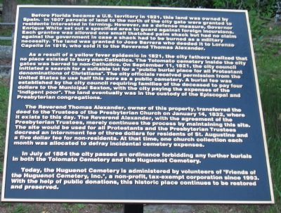
As a result of a yellow fever epidemic in 1821, the city fathers realized that no place existed to bury non-Catholics. The Tolomato cemetery inside the city gates was barred to non-Catholics. On September 11, 1821, the city council initiated a search for a suitable lot for a "public burial place for all Protestant denominations of Christians." The city officials received permission from the United States to use half this acre as a public cemetery. A burial fee was established by the city council requiring families of the deceased to pay four dollars to the Municipal Sexton, with the city paying the expenses of the "indigent poor". The land eventually was in the custody of the Episcopal and Presbyterian congregations.
The Reverend Thomas Alexander, owner of this property, transferred the deed to the Trustees of the Presbyterian Church on January 14, 1832, where it exists to this day. The Reverend Alexander, with the agreement of the Presbyterian Trustees, merely continues the process by maintaining this site. The site would be used for all Protestants and the Presbyterian Trustees decreed an internment fee of three dollars for residents of St. Augustine and a five dollar fee for non-residents. At that time, one church collection each month was allocated to defray incidental cemetery expenses.
In July of 1884 the city passed an ordinance forbidding any further burials in both the Tolomato Cemetery and the Huguenot Cemetery.
Today, the Huguenot Cemetery is administered by volunteers of "Friends of the Huguenot Cemetery, Inc.", a non-profit, tax-exempt corporation since 1993. With the help of public donations, this historic place continues to be restored and preserved.
(Second Plaque):
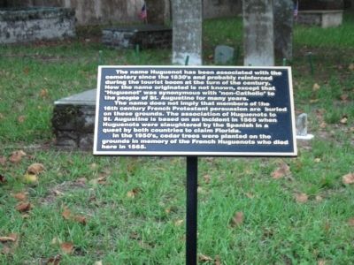
The name Huguenot has been associated with the cemetery since the 1830's and probably reinforced during the tourist boom at the turn of the century. How the name originated is not known, except that "Huguenot" was synonymous with "non-Catholic" to the people of St. Augustine for many years.
The name does not imply that members of the 16th century French Protestant persuasion are buried on these grounds. The association of Huguenots to St. Augustine is based on an incident in 1565 when Huguenots were slaughtered by the Spanish in a quest by both countries to claim Florida.
In the 1950's, cedar trees were planted on the grounds in memory of the French Huguenots who died here in 1565.
Topics. This historical marker is listed in this topic list: Cemeteries & Burial Sites. A significant historical month for this entry is January 1821.
Location. 29° 53.893′ N, 81° 18.833′ W. Marker is in St. Augustine, Florida, in St. Johns County. It is in the Historic District. Marker is on North Ocean Boulevard (State Road A1A), on the right when traveling south. Touch for map. Marker is at or near this postal address: 2 St George St, Saint Augustine FL 32084, United States of America. Touch for directions.
Other nearby markers. At least 8 other markers are within walking distance of this marker. Public Burying Ground (a few steps from this marker); Safe Haven / Refugio seguro (within shouting distance of this marker); Old Spanish Trail Zero Milestone (within shouting distance of this marker); This Gate Opened in 1739 (within shouting distance of this marker); Fuente de los Caños de San Francisco (within shouting distance of this marker); The City Gate (within shouting distance of this marker); St. Augustine Civic Center (within shouting distance of this marker); a different marker also named The Huguenot Cemetery (within shouting distance of this marker). Touch for a list and map of all markers in St. Augustine.
Credits. This page was last revised on January 2, 2019. It was originally submitted on August 31, 2011, by Craig Swain of Leesburg, Virginia. This page has been viewed 1,130 times since then and 23 times this year. Photos: 1, 2, 3, 4. submitted on August 31, 2011, by Craig Swain of Leesburg, Virginia.


