Superior in Douglas County, Wisconsin — The American Midwest (Great Lakes)
Lake Superior
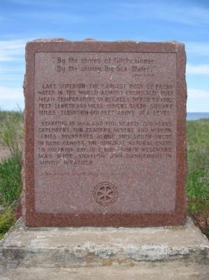
By the shining Big-Sea-Water,"
Lake Superior - the largest body of fresh water in the world - almost chemically pure - mean temperature 39 degrees - depth to 1302 feet - length 383 miles - covers 31,820 square miles - elevation 601 feet above sea level.
Starting in 1666 and for nearly 200 years, explorers, fur traders, miners and missionaries journeyed along this south shore in bark canoes. The original natural entry to Superior Bay, one mile north-westward, was wide, shallow, and dangerous in windy weather.
Turn around and plaque by Superior Rotary Club 1957
Erected 1957 by Superior Rotary Club.
Topics and series. This historical marker is listed in this topic list: Waterways & Vessels. In addition, it is included in the Rotary International series list. A significant historical year for this entry is 1302.
Location. 46° 41.495′ N, 91° 59.137′ W. Marker is in Superior, Wisconsin, in Douglas County. Marker is on Wisconsin Point Road, 1.7 miles north of Moccasin Mike Road, on the right when traveling north . Moccasin Mike Road can be reached from the intersection of US Highway 2 / 53 and County Highway E. Touch for map. Marker is in this post office area: Superior WI 54880, United States of America. Touch for directions.
Other nearby markers. At least 8 other markers are within 5 miles of this marker, measured as the crow flies. Burial Ground of the Fond du Lac Band (approx. 1.3 miles away); Superior Entry South Breakwater Light (approx. 1˝ miles away); The Superior Entry (approx. 1.7 miles away); Northwest Portal of Wisconsin (approx. 1.9 miles away); Burlington Northern Ore Docks (approx. 2.1 miles away); Old Stockade Site (approx. 3˝ miles away); Duluth-Superior Harbor (approx. 3˝ miles away); S.S. Meteor (approx. 4.3 miles away). Touch for a list and map of all markers in Superior.
Also see . . .
1. Lake Superior. Wikipedia entry. (Submitted on September 10, 2011.)
2. Lake Superior Facts. (Submitted on September 10, 2011.)
Credits. This page was last revised on November 23, 2020. It was originally submitted on September 10, 2011, by Keith L of Wisconsin Rapids, Wisconsin. This page has been viewed 703 times since then and 25 times this year. Photos: 1, 2, 3, 4. submitted on September 10, 2011, by Keith L of Wisconsin Rapids, Wisconsin.


