Ridgedale in Taney County, Missouri — The American Midwest (Upper Plains)
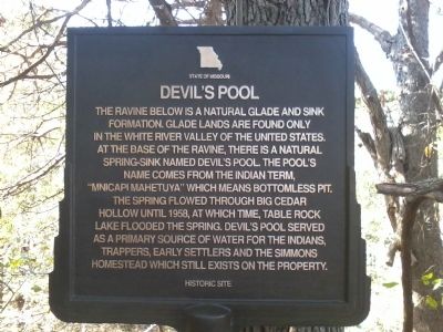
Devil's Pool
Photographed by Richard Denney, October 9, 2011
1. Devil's Pool Marker
Topics. This historical marker is listed in these topic lists: Indigenous Peoples and Communities • Settlements & Settlers. A significant historical year for this entry is 1958.
Location. 36° 32.051′ N, 93° 16.425′ W. Marker is in Ridgedale, Missouri, in Taney County. It can be reached from Ravine Drive, on the right when traveling east. Touch for map. Marker is in this post office area: Ridgedale MO 65739, United States of America. Touch for directions.

Regionally, this marker is in Southwest Missouri and in the Branson and Table Rock Lake Area. It is also in
this page online
Other nearby markers. At least 8 other markers are within 6 miles of this marker, measured as the crow flies: College of the Ozarks Veterans Grove (approx. 5.8 miles away); Patriots Park (approx. 5.8 miles away); The Korean War Memorial (approx. 5.8 miles away); Veterans Grove (approx. 5.8 miles away); The Missouri Gold Star Families Memorial (approx. 5.8 miles away); In Honor of the Unknown Soldier (approx. 5.9 miles away); The Missouri Vietnam Veterans Memorial (approx. 5.9 miles away); The Global War On Terrorism Memorial (approx. 5.9 miles away).
Photographed by Richard Denney, October 9, 2011
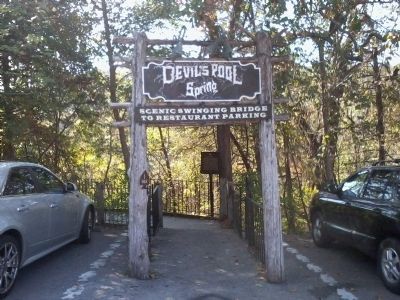
2. Marker in context
Marker is at entrance to the swinging bridge overlooking Devil's Pool, on the property of the Big Cedar Lodge.
Credits. This page was last revised on June 16, 2016. It was originally submitted on October 10, 2011, by Richard Denney of Austin, Texas. This page has been viewed 6,011 times since then and 360 times this year. Photos: 1, 2. submitted on October 10, 2011, by Richard Denney of Austin, Texas. • Craig Swain was the editor who published this page.
