
Streetscape 1859
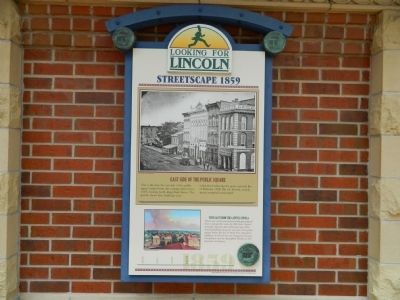
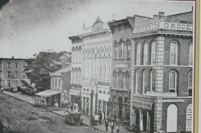
East Side of the Public Square
| — | Looking for Lincoln | — |
This is the
View east from the capitol cupola
This is one of four panoramic landscapes painted from a perspective atop the Old State Capitol sometime between late 1848 and early 1854, showing buildings along the east side of the public square before the fire of 1858. The columned buildings on the left are the Sangamon County Courthouse and the Springfield Marine & Fire Insurance Company.
Erected by State of Illinois Historic Preservation Agency & Looking for Lincoln Heritage Coalition.
Topics and series. This historical marker is listed in these topic lists: Architecture • Government & Politics. In addition, it is included in the Former U.S. Presidents: #16 Abraham Lincoln, and the Looking for Lincoln series lists. A significant historical month for this entry is February 1858.
Location. 39° 48.037′ N, 89° 38.884′ W. Marker is in Springfield, Illinois, in
this page online

Regionally, this marker is in Central Illinois. It is also in the American Midwest and in the Corn Belt. Globally, it is in North America, the Western Hemisphere, the Western World, and the Anglosphere. Historically, it finds itself in what was once the territory of the Mississippian Culture and also the Northwest Territory.
Other nearby markers. At least 8 other markers are within walking distance of this marker: The Lincoln Boys in 1854 (here, next to this marker); In Their Springfield Prime (a few steps from this marker); Lincoln's Springfield (a few steps from this marker); Old State Capitol (a few steps from this marker); Barack Obama Campaign Announcements (a few steps from this marker); Lincoln-Herndon Law Offices (a few steps from this marker); Cook's Hall (within shouting distance of this marker); Corneau & Diller Drug Store (within shouting distance of this marker). Touch for a list and map
Credits. This page was last revised on December 14, 2024. It was originally submitted on October 20, 2011, by Bill Pfingsten of Bel Air, Maryland. This page has been viewed 632 times since then and 14 times this year. Photos: 1, 2. submitted on October 20, 2011, by Bill Pfingsten of Bel Air, Maryland.
