Padgett's Creek in Union County, South Carolina — The American South (South Atlantic)
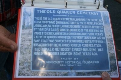
The Old Quaker Cemetary
Erected 1961 by the Union County Historical Foundation and C. B. McGrady.
Topics and series. This historical marker is listed in these topic lists: Cemeteries & Burial Sites • Churches & Religion • Settlements & Settlers. In addition, it is included in the Quakerism series list. A significant historical month for this entry is May 1822.
Location. Marker has been reported missing. It was located near 34° 35.508′ N, 81° 42.04′ W. Marker was in Padgett's Creek, South Carolina, in Union County. Marker could be reached from Old Buncombe Road (State Highway S-44-18) 0.1 miles east of Galilee Church Road (State Highway S-44-63). Touch for map. Marker was in this post office area: Union SC 29379, United States of America. Touch for directions.
Other nearby markers. At least 8 other markers are within 8 miles of this location, measured as the crow flies. Gist Cemetery (approx. 1.4 miles away); Rose Hill Mansion (approx. 2.2 miles away); Padgett’s Creek Baptist Church (approx. 3.3 miles away); Cross Keys House (approx. 5 miles away); Fair Forest Plantation / Emslie Nicholson House (approx. 6.2 miles away); Fairforest Meeting (approx. 6.4 miles away); Otterson's Fort (approx. 6.4 miles away); Veterans Memorial (approx. 7.4 miles away).
Credits. This page was last revised on February 3, 2020. It was originally submitted on October 31, 2010, by Wes Cox of Union, South Carolina. This page has been viewed 1,471 times since then and 76 times this year. Last updated on October 21, 2011, by James Edward Edmundson of Clifton, Virginia. Photo 1. submitted on October 31, 2010, by Wes Cox of Union, South Carolina. • Craig Swain was the editor who published this page.
