Camden in Kershaw County, South Carolina — The American South (South Atlantic)
Historic Camden Revolutionary War Site
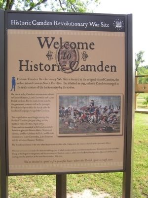
Welcome to Historic Camden
On June 1, 1780, Camden’s citizens surrendered to General Charles, Lord Cornwallis and 2,500 British soldiers. For the next eleven months the garrisoned town served as the principal British inland post while the brutal 1780 - 81 Southern Campaign ravaged the Carolinas.
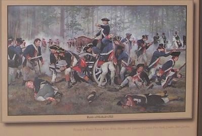
Two major battles were fought nearby: the Battle of Camden (August 1780) and the Battle of Hobkirk’s Hill (April 1781). Commanders associated with Camden include American generals Horatio Gates, Nathanael Greene, and Baron Johann de Kalb, and British commanders Lord Cornwallis, Lord Rawdon and the infamous Banastre Tarleton.
The British burned most of the town when they evacuated in May 1781. Undaunted, the citizens rebuilt Camden just north of here.
This 107 ~ acre museum includes five historic buildings, two of which contain exhibits, reconstructions of several British fortifications unearthed during archaeological investigations, and the reconstructed Kershaw mansion, which served as British headquarters. Historic Camden is the starting point for your tour of the area’s Revolutionary War sites.
You’re invited to spend a few peaceful hours where the British spent a rough year.
Topics. This historical marker is listed in this topic list: War, US Revolutionary. A significant historical month for this entry is May 1781.
Location. 34° 14.003′ N, 80° 36.208′ W. Marker is in Camden, South Carolina, in Kershaw County. Marker can be reached from Broad Street. Located in the Historic Camden Revolutionary War Site. Touch for map. Marker is in this post office area: Camden SC 29020, United States of America. Touch for directions.
Other nearby markers. At least 8 other markers are within walking distance of this marker. American Commanders (here, next to this marker); British Commanders (here, next to this marker); African Americans Choose Sides (within shouting distance of this marker); War in the Backcountry (within shouting distance of this marker); Citizen - Soldiers (about 300 feet away, measured in a direct line); The Fortified Post (about 300 feet away); Palisade Wall (about 300 feet away); Camden - Strategic Key (about 400 feet away). Touch for a list and map of all markers in Camden.

Photographed By Anna Inbody, October 2, 2011
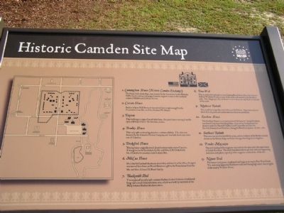
4. Historic Camden Revolutionary War Site Map
1. Cunningham House (Historic Camden Exchange) The house, built about 1840, was donated to the foundation by the Nicholas Gaffon family and moved in 1971 from its original location at the southeast corner of Market and DeKalb Streets.
2. Craven House Built in 1789 on Mill Street, it was moved here in 1970 as a gift to the Foundation from Mr. and Mrs. Richard W. Lloyd.
3. Dogtrot This building is a copy of an old style barn, the quaint name coming from the open walkway between the two main rooms.
4. Bradley House This early 19th~century log structure contains exhibits. The cabin was donated by the Catawba Timber Company and was built about nine miles east of Camden.
5. Drakeford House This log house originally stood about fourteen miles above Camden. It was given to the foundation by Mr. and Mrs. E. H. Drakeford; Mr. Drakeford’s ancestors built it about 1812.
6. McCaa House Dr. John McCaa built this house about 1825 and used it as his office. In 1991 it was moved here from 511 Broad Street as a gift to the Foundation from the Mr. and Mrs. Edward B. Beard family.
7. Blacksmith Shed This replica of an early 19th~century blacksmith shed features a traditional forge and a small demonstration area, which was built by members of the Philip Simons Blacksmith Association.
8. Town Wall The reconstructed palisade sections flanking Broad Street (then the Catawba Path or Waxhaws Road) are part of the south wall erected by the British in 1780. The village lay to the north and covered about one city block on each side of the road.
9. Northeast Redoubt This small fort originally extended across Bull Street. Approximately one third of its dry moat and earthworks have been reconstructed.
10. Kershaw House The Kershaw House is a reconstruction of the home of Joseph Kershaw, considered Camden’s founding father. It served as headquarters for about 6 weeks for General Charles, Lord Cornwallis and later for Lt. Col. Francis, Lord Rawdon, during the British occupation of 1780 - 1781.
11. Southeast Redoubt This area was used for landfill for years, and no evidence of the British redoubt shown on the Greene Map was found during archaeological investigation.
12. Powder Magazine The 1777 brick powder magazine was built for the state under the supervision of Joseph Kershaw. The brick foundation shows 48~inch walls and supporting buttresses and pillars, typical powder magazine construction of the era.
13. Nature Trail The nature trail passes a small pond and bogs on its way to Pine Tree Creek. The waterway supported Kershaw’s mills and during high water was navigable to the nearby Wateree River.
Credits. This page was last revised on June 16, 2016. It was originally submitted on October 28, 2011, by Anna Inbody of Columbia, South Carolina. This page has been viewed 1,094 times since then and 27 times this year. Photos: 1, 2, 3, 4. submitted on October 28, 2011, by Anna Inbody of Columbia, South Carolina. • Craig Swain was the editor who published this page.


