Liberty Island in Manhattan in New York County, New York — The American Northeast (Mid-Atlantic)
The Manhattan Skyline
Photographed by Bill Coughlin, November 7, 2011
1. The Manhattan Skyline Marker
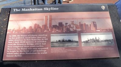
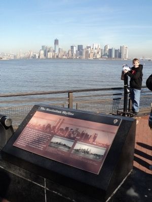
In 1886, the Statue of Liberty standing on her pedestal, stood taller than any other structure in New York City. At 305 feet, 1 inch (92.99 meters), it exceeded even the Brooklyn Bridge, which had been completed three years earlier. However, the Statue was soon surpassed in height by the forest of tall buildings which today gives Manhattan its world-famous skyline.
Erected by National Park Service, U.S. Department of the Interior.
Topics. This historical marker is listed in these topic lists: Arts, Letters, Music • Landmarks • Notable Places. A significant historical year for this entry is 1886.
Location. 40° 41.444′ N, 74° 2.72′ W. Marker is in Manhattan, New York, in New York County. It is on Liberty Island. It can be reached from no nearby street. Marker is located on the north end of Liberty Island. Touch for map. Marker is in this post office area: New York NY 10004, United States of America. Touch for directions.

Regionally, this marker is in New York City. It is also in the American Northeast, in the Mid-Atlantic, and on the Eastern Seaboard. Globally, it is in the North Atlantic Region, North
this page online
Other nearby markers. At least 8 other markers are within walking distance of this marker: Immigrant Processing in New York (here, next to this marker); Joseph Pulitzer (about 400 feet away, measured in a direct line); Emma Lazarus (about 400 feet away); Edouard Rene De Laboulaye (about 400 feet away); Frederic Auguste Bartholdi (about 400 feet away); Alexandre Gustave Eiffel (about 400 feet away); Inside the Statue (about 400 feet away); Symbolism (about 400 feet away). Touch for a list and map of all markers in Manhattan.
More about this marker. The top of the marker features a picture of the Lower Manhattan skyline as it appeared in 1997. Buildings are identified, including: the Empire State Building, World Financial Center, World Trade Center, Woolworth Building, Bank of Manhattan, U.S. Customs House, City Bank – Farmer’s Trust Company, and Brooklyn Bridge. At the lower right of the marker are two photographs of the Manhattan Skyline. The
Photographed by Bill Coughlin, November 7, 2011
2. The Manhattan Skyline and Marker
Photographed by Dominic Deeble, circa May 24, 2015
3. The Manhattan Skyline - 2015
Photographed by Bill Coughlin, November 7, 2011
4. The Manhattan Skyline
Credits. This page was last revised on February 24, 2026. It was originally submitted on November 8, 2011, by Bill Coughlin of Woodland Park, New Jersey. This page has been viewed 812 times since then and 37 times this year. Photos: 1, 2. submitted on November 8, 2011, by Bill Coughlin of Woodland Park, New Jersey. 3. submitted on August 16, 2015, by Carolyn Martienssen of West Hazleton, Pennsylvania. 4. submitted on November 8, 2011, by Bill Coughlin of Woodland Park, New Jersey.
