Lee Vining in Mono County, California — The American West (Pacific Coastal)
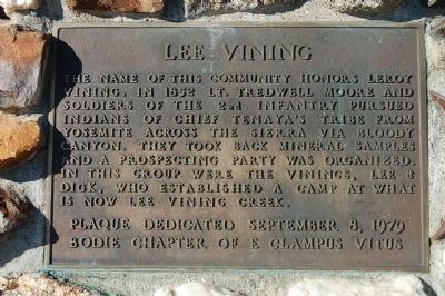
Lee Vining
Erected 1979 by E Clampus Vitus, Bodie Chapter No. 64.
Topics and series. This historical marker is listed in these topic lists: Exploration • Settlements & Settlers. In addition, it is included in the E Clampus Vitus series list. A significant historical year for this entry is 1852.
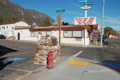
Location. 37° 57.357′ N, 119° 7.139′ W. Marker is in Lee Vining, California, in Mono County. Marker is at the intersection of Three Flags Highway (State Highway 395) and 4th Street, on the right when traveling south on Three Flags Highway. Touch for map. Marker is in this post office area: Lee Vining CA 93541, United States of America. Touch for directions.
Other nearby markers. At least 8 other markers are within 6 miles of this marker, measured as the crow flies. Upside-Down House (approx. 0.2 miles away); Mono Lake (approx. ¾ mile away); Sheriff James P. Dolan (approx. 1.7 miles away); Grave of Adeline Carson Stilts (approx. 4.1 miles away); Grave of the Unknown Prospector (approx. 5 miles away); Navy Beach (approx. 5.6 miles away); Would-Be Miners and Occasional Tourists (approx. 6.1 miles away); The Tioga Pass Road (approx. 6.1 miles away). Touch for a list and map of all markers in Lee Vining.
Credits. This page was last revised on June 16, 2016. It was originally submitted on November 29, 2011, by Barry Swackhamer of Brentwood, California. This page has been viewed 1,006 times since then and 36 times this year. Photos: 1, 2, 3. submitted on November 29, 2011, by Barry Swackhamer of Brentwood, California. • Syd Whittle was the editor who published this page.


