Sandy Hook in Washington County, Maryland — The American Northeast (Mid-Atlantic)
Charcoal Making on Maryland Heights
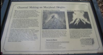
The charcoal industry required wood; Maryland Heights offered plenty. From 1810 to 1848 the Antietam Iron Works, 7 miles to the north, cut trees on the mountain to make charcoal to fuel its furnace and forges. The burning charcoal helped produce refined iron, from which the Antietam Iron Works made nails and other tools.
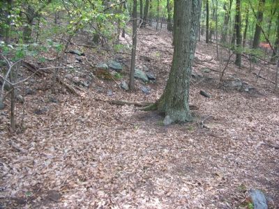
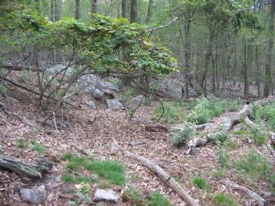
Just above you are the remains of a typical charcoal hearth, one of 57 recorded on the 783 acres of Maryland Heights. Colliers, the skilled men who made the charcoal, formed a hearth by clearing a level oblong platform on the mountain slope. Over a ten-day burning period, a hearth transformed 50 cords of wood into 1750 bushels of charcoal.
Crude sled and wagon roads formed the arteries of the charcoal industry. After cutting a woodlot, laborers dragged timber downhill along a sled road to a hearth, where the colliers made the charcoal. Then via wagon roads, teamsters hauled the charcoal off the mountain to the ironworks. Over time, about 23 miles of road covered these Heights. Many were later improved by Civil War soldiers. Some you hike today.
Building a Charcoal Pit
The collier first built a triangular chimney in the center of the hearth and filled it with wood chips and other flammable material. Next he stacked 30 to 50 cords of wood tightly around the chimney. Leaves and a layer of dirt and charcoal dust completed the pit. The chimney was lit from the top and covered.
Tending the Charring
A burning hearth produced tremendous smoke. It needed constant care to prevent fire from burning through the outer layer. If too much air entered the stack, an open flame reduced the wood to useless ash. The demands of charring required a collier to live in a make-shift hut near the hearth during the burning period.
Acres to Burn
• An iron works factor owned vast acres of hardwood forest which supplied charcoal to fuel their furnaces.
• One cord of wood is 128 cubic feet.
• Thirty cords equals one acre.
• A charcoal hearth burned two acres.
• A furnace burned up 276 acres annually.
Topics. This historical marker is listed in these topic lists: Industry & Commerce • Natural Resources. A significant historical year for this entry is 1810.
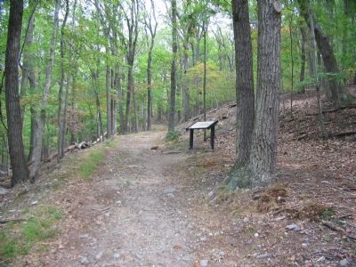
Location. 39° 20.079′ N, 77° 43.448′ W. Marker is in Sandy Hook, Maryland, in Washington County. Marker can be reached from Sandy Hook Road. Located at a wayside trail stop on the Stone Fort Trail loop, Maryland Heights, in Harpers Ferry National Historic Park. Touch for map. Marker is in this post office area: Knoxville MD 21758, United States of America. Touch for directions.
Other nearby markers. At least 8 other markers are within walking distance of this marker. Making a Mountain Citadel (about 400 feet away, measured in a direct line); 30-Pounder Battery (approx. 0.2 miles away); Hiking Maryland Heights (approx. ¼ mile away); Civil War Campgrounds (approx. ¼ mile away); 100 - Pounder Battery - Heaviest and Highest (approx. ¼ mile away); Naval Battery (approx. 0.3 miles away); Maryland Heights - Mountain Fortress of Harpers Ferry (approx. 0.4 miles away); Exterior Fort (approx. half a mile away). Touch for a list and map of all markers in Sandy Hook.
More about this marker. Drawings on the marker illustrate the building of a charcoal pit and the burning of the hearth. Another drawing illustrates a cord of wood was 8 feet long by 4 feet wide by six feet tall.
Regarding Charcoal Making on Maryland Heights. This marker is one of a set along the National Park Service's trail to the top of Maryland Heights.
Related marker. Click here for another marker that is related to this marker. Antietam Iron Works Bridge (mentioned on this wayside)
Credits. This page was last revised on May 2, 2022. It was originally submitted on January 27, 2008, by Craig Swain of Leesburg, Virginia. This page has been viewed 1,623 times since then and 22 times this year. Photos: 1, 2, 3, 4. submitted on January 27, 2008, by Craig Swain of Leesburg, Virginia.


