Monticello in Lawrence County, Mississippi — The American South (East South Central)
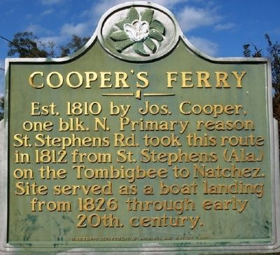
Cooper's Ferry
Erected 1985 by Mississippi Department of Archives and History.
Topics and series. This historical marker is listed in this topic list: Waterways & Vessels. In addition, it is included in the Mississippi State Historical Marker Program series list. A significant historical year for this entry is 1810.
Location. 31° 33.301′ N, 90° 6.508′ W. Marker is in Monticello, Mississippi, in Lawrence County. Marker is on Brookhaven Street, on the right when traveling north. Touch for map. Marker is in this post office area: Monticello MS 39654, United States of America. Touch for directions.
Other nearby markers. At least 5 other markers are within 14 miles of this marker, measured as the crow flies. J. B. Lenoir (about 500 feet away, measured in a direct line); A. H. Longino (approx. 0.3 miles away); Gov. A.H. Longino House (approx. 0.3 miles away); East Lincoln High School (approx. 11.7 miles away); First Choctaw Cession (approx. 13˝ miles away).
Credits. This page was last revised on June 16, 2016. It was originally submitted on December 4, 2011, by Jeff Lovorn of Florence, Mississippi. This page has been viewed 600 times since then and 36 times this year. Photos: 1. submitted on December 4, 2011, by Jeff Lovorn of Florence, Mississippi. 2. submitted on January 4, 2014, by Robert M. Cook, Jr. of Biloxi, Mississippi. • Craig Swain was the editor who published this page.

