Oma in Lawrence County, Mississippi — The American South (East South Central)
First Choctaw Cession
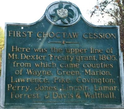
Photographed by Jeff Lovorn, November 19, 2011
1. First Choctaw Cession Marker
Erected 1982 by Mississippi Department of Archives and History.
Topics and series. This historical marker is listed in this topic list: Settlements & Settlers. In addition, it is included in the Mississippi State Historical Marker Program series list. A significant historical year for this entry is 1805.
Location. 31° 44.819′ N, 90° 8.884′ W. Marker is in Oma, Mississippi, in Lawrence County. It is on State Highway 27, on the right when traveling south. Touch for map. Marker is in this post office area: Monticello MS 39654, United States of America. Touch for directions.

Regionally, this marker is in Southwest Mississippi and in the Pine Belt. It is also in the American South, specifically in the Deep South, and in the Piney Woods. Globally, it is in North America, a Gulf of Mexico state, the Western Hemisphere, the Western World, and the Anglosphere. Historically, it finds itself in what was once the territory
this page online
Other nearby markers. At least 8 other markers are within 14 miles of this marker, measured as the crow flies: Smith/Furr Pioneer Homesite (approx. 11.2 miles away); Old Silver Creek Baptist Church (approx. 13.1 miles away); Cooper's Ferry (approx. 13½ miles away); J. B. Lenoir (approx. 13.6 miles away); Harmon Runnels (approx. 13.6 miles away); A. H. Longino (approx. 13.6 miles away); Gov. A.H. Longino House (approx. 13.6 miles away); St. Stephens Road (approx. 13.8 miles away).
Credits. This page was last revised on June 16, 2016. It was originally submitted on December 4, 2011, by Jeff Lovorn of Florence, Mississippi. This page has been viewed 930 times since then and 51 times this year. Photo 1. submitted on December 4, 2011, by Jeff Lovorn of Florence, Mississippi. • Craig Swain was the editor who published this page.
Editor’s want-list for this marker. A wide view photo of the marker and the surrounding area in context. • Can you help?
