Cape Elizabeth in Cumberland County, Maine — The American Northeast (New England)
Looking North
Portland, Maine
Population: 65,000
Surrounding Population: 250,000
Number of Languages Spoken in the Portland Public Schools: 40
Visitors Per Year: 3,750,000
Average Summer Temperature: 82°
Miles from Boston: 100
Amount of office space in downtown, in millions of sq ft: 4,000
Arts events each year: 2,000
(over 50% are free)
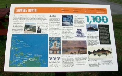
The motto of Portland, Maine's largest city, is "Resurgam" ("I will rise again"), reflecting the city's resilience after four catastrophic fires from 1690 to 1886. The last destroyed 2,000 buildings and left 75% of the population homeless. Portland is considered the state's cultural, social, and economic hub.
Theater and Casino
Cape Cottage Theater stood at Shore and Surf Roads. In the late 1800s a round-trip trolley from Portland was twenty cents, including admission to the summer theater. Near the end of every performance, the audience could hear the squealing of the wheels on the tracks as the trolley cars lined up in front of the theater to take patrons back to Portland.
Colonel John Goddard
At the time of the Civil War, Colonel John Goddard was te wealthiest man in Cape Elizabeth. Goddard was responsible for organizing the First Maine Cavalry. His former residence is located in Fort Williams Park, near Ship Cove.
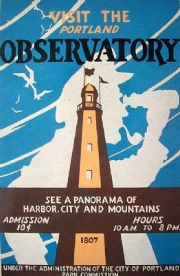
The Portland Observatory
The Portland Observatory is the only extant maritime signal station in the United States. The Observatory became a National Historic Landmark in 2006.
Sea captain-turned-entrepreneur Lemuel Moody (1768-1846) ordered construction of this octagonal, 86' high tower to serve as a communication station for Portland's bustling harbor. With his powerful telescope, Moody identified incoming vessels and then used coded signal flags to alert merchants, allowing them ample time to reserve a birth on the wharves and to hire a crew of stevedores before the vessel docked.
From the time it opened in 1807 (when it included dance halls and a bowling alley), the Portland Observatory was a tourist attraction.
Liberty Ship Memorial
Located on the site of the former shipyards, the Liberty Ship Memorial stands in tribute to the New England Shipbuilding Corporation and the thousands of men and women who built and sailed on Liberty cargo ships during WWII.
The Liberty Ship Memorial is located in Bug Light Park, South Portland. Two hundred sixty-six Liberty Ships were built in South Portland from 1941 to 1945.
Portland Marine Society
In 1796, the stated purposes of Portland's new society were two-fold: first, "the promotion of the knowledge of navigation and seamanship," and second, "the relief of decayed and disabled seamen, and the poor widows and orphans of deceased seamen."
The Portland Marine Society is still active today and is located on Commercial Street in Portland.
Portland Montreal Pipeline
Since it first opened in the autumn of 1941, Portland Montreal Pipeline has delivered over four billion barrels of crude oil to Canada.
PMPL owns and operates a tanker unloading facility, two tank farms (South Portland, Maines, and Montreal, Quebec) and a system of pump stations and crude oil pipelines that traverse 236 miles along a common right-of-way from Maine to Quebec.
Early Portland
Portland was called "Machigonne" by the native people who lived in the area. The first European settler was Christopher Levett, an English sea captain, who, in 1623, was granted 6000 acres by the King to establish a settlement in Casco Bay. Captain Levett suggested the name "York." He was unable to drum up support for the settlement, and the next permanent settlement was not until 1632, also by the English. The town was renamed "Casco," and then "Falmouth" in 1658. A monument on the Eastern Promenade commemorates the four historical names.
Coastal Fortifications
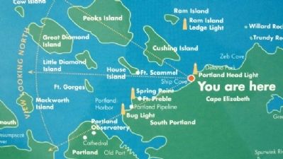
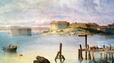
Following the War of 1812, the Army Corps of Engineers proposed that a fort be built on Hog Island Ledge in Casco Bay, at
the entrance to Portland Harbor. Named for the colonial proprietor of Maine, Sir Ferdinando Gorges, it was designed to support existing forts, including Fort Scammel, built on nearby House Island in 1808.
Congress, however, did not fund construction of Fort Gorges until 1857. Fort Preble, on the campus of Southern Maine Community College in South Portland, was built in 1808 and named in honor of Commodore Edward Preble.
This painting hangs in the U.S. Capitol in Washington, D.C.
Fishing Industry
Portland has a large fleet of deep-sea fishing vessels, which offload their catch including, cod, haddock, scallops, and shrimp, primarily at the Portland Fish Exchange.
Numerous towns and islands also serve as ports for lobster boats. Maine has more than 7,000 miles of coastline; however, only 25 of them are used as "working waterfronts."
North Atlantic Fleet
During World War II, Portland served as the home base for the North Atlantic Fleet of the U.S. Navy from 1940-1945.
[Miscellaneous Fact]
1,100 - It is said that Portland has more restaurants per capita than any other U.S. city except San Francisco.
Topics. This historical marker is listed in this topic list: Notable Places. A significant historical year for this entry is 1690.
Location. 43° 37.434′ N, 70° 12.675′ W. Marker is in Cape Elizabeth, Maine, in Cumberland County. Marker is on the hill, about 1000 feet WNW of Portland Head Light, in Fort Williams Park, off Shore Road. Touch for map. Marker is in this post office area: Cape Elizabeth ME 04107, United States of America. Touch for directions.
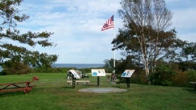
Other nearby markers. At least 8 other markers are within walking distance of this marker. Looking East (here, next to this marker); Looking South (here, next to this marker); Battery Hobart (about 400 feet away, measured in a direct line); Mining Casemate (about 500 feet away); Battery Blair (about 500 feet away); Fort Williams (about 600 feet away); Daily Life (about 600 feet away); Civilian Conservation Corps (about 600 feet away). Touch for a list and map of all markers in Cape Elizabeth.
Credits. This page was last revised on December 8, 2021. It was originally submitted on December 10, 2011, by William Fischer, Jr. of Scranton, Pennsylvania. This page has been viewed 1,091 times since then and 12 times this year. Photos: 1, 2. submitted on December 10, 2011, by William Fischer, Jr. of Scranton, Pennsylvania. 3. submitted on December 11, 2011, by William Fischer, Jr. of Scranton, Pennsylvania. 4, 5, 6. submitted on December 10, 2011, by William Fischer, Jr. of Scranton, Pennsylvania. 7. submitted on November 28, 2021, by Craig Doda of Napoleon, Ohio.
