Downtown Las Vegas in Clark County, Nevada — The American Mountains (Southwest)
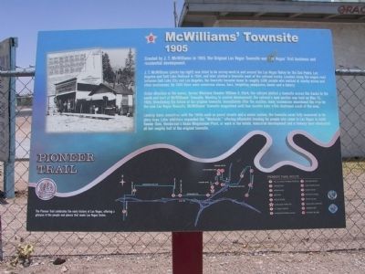
McWilliams' Townsite
1905
J.T. McWilliams (photo top right) was hired to do survey work in and around the Las Vegas Valley for the San Pedro, Loas Angeles and Salt Lake Railroad in 1904, and later platted a townsite west of the railroad tracks. Located along the wagon road between Salt Lake City and Los Angeles, the townsite became home to roughly 1,500 people who worked at nearby mines and other businesses. By 1905 there were numerous stores, bars, freighting companies, banks and a bakery.
Under direction of the owner, former Montana Senator William A. Clark, the railroad platted a townsite across the tracks to the south and east of McWilliam's Townsite. Wanting to control development, the railroad's land auction was held on May 15, 1905, threatening the future of the original townsite. Immediately after the auction, man businesses abandoned the area for the new Las Vegas Townsite. McWilliams' Townsite languished until four months later a fire destroyed much of the area.
Lacking basic amenities until the 1940s such as paved streets and a sewer system, the townsite never fully recovered to is glory days. Later additions expanded the "Westside," offering affordable housing for people who came to Las Vegas to build Hoover Dam, Henderson's Basic Magnesium Plant, or work in the hotels. Industrial development and a freeway have eliminated all but roughly half of the original townsite.
Erected by the City of Las Vegas, Clark County, Preserve America & the Southern Nevada Public Lands Management Act. (Marker Number 6.)
Topics. This historical marker is listed in this topic list: Settlements & Settlers. A significant historical month for this entry is May 1955.
Location. 36° 10.746′ N, 115° 9.107′ W. Marker is in Las Vegas, Nevada, in Clark County. It is in Downtown Las Vegas. Marker is at the intersection of H Street and West McWilliams Avenue, on the right when traveling north on H Street. Touch for map. Marker is at or near this postal address: 721 H Street, Las Vegas NV 89106, United States of America. Touch for directions.
Other nearby markers. At least 8 other markers are within walking distance of this marker. St. James the Apostle (about 400 feet away, measured in a direct line); Moulin Rouge (approx. 0.2 miles away); Harrison Boarding House (approx. ¼ mile away); Westside School (approx. 0.3 miles away); Jackson Street Commercial District (approx. half a mile away); Christensen House "The Castle" (approx. 0.6 miles away); Moody House (approx. 0.6 miles away); The First Telephone (approx. 0.6 miles away). Touch for a list and map of all markers in Las Vegas.
Related markers.
Click here for a list of markers that are related to this marker. The Pioneer Trail - West Las Vegas
Also see . . . McWilliams Townsite page for www.LasVegasPioneerTrail.com. Visit the www.LasVegasPioneerTrail.com to learn more about the McWilliams Townsite (Submitted on October 31, 2020, by Deuce Brandt of North Las Vegas, Nevada.)
Credits. This page was last revised on February 7, 2023. It was originally submitted on December 7, 2011, by Michael Kindig of Elk Grove, California. This page has been viewed 1,332 times since then and 90 times this year. Last updated on December 28, 2011, by Michael Kindig of Elk Grove, California. Photos: 1, 2. submitted on December 7, 2011, by Michael Kindig of Elk Grove, California. • Syd Whittle was the editor who published this page.

