Sayreville in Middlesex County, New Jersey — The American Northeast (Mid-Atlantic)
Sayreville, New Jersey Time Capsule
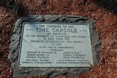
Time Capsule
are presented
to the residents of Sayreville, New Jersey
in 2076 from the
residents of Sayreville, New Jersey
in 1976
Mayor John E Czernikowsky
Councilmen
John Singer - President, Sayreville Historical Society
John B. McCormack - Chairperson, Sayreville Bicentennial Committee
Erected 1976 by Sayreville Historical Society.
Topics and series. This historical marker is listed in this topic list: Settlements & Settlers. In addition, it is included in the The Spirit of ’76, America’s Bicentennial Celebration, and the Time Capsules series lists. A significant historical year for this entry is 2076.
Location. 40° 27.818′ N, 74° 21.707′ W. Marker is in Sayreville, New Jersey, in Middlesex County. Marker is on Main Street (New Jersey Route 670) near Veterans Drive. Touch for map. Marker is at or near this postal address: 167 Main Street, Sayreville NJ 08872, United States of America. Touch for directions.
Other nearby markers. At least 8 other markers are within 2 miles of this marker, measured as the crow flies. Sayre and Fisher Brick Water Tower (approx. half a mile away); Sayre & Fisher Reading Room (approx. 0.6 miles away); Sayreville United Methodist Church (approx. ¾ mile away); Cannon Brothers' Park (approx. 0.9 miles away); Old School Baptist Church (approx. 1.4 miles away); South River World War II, Korean Conflict, and Vietnam Conflict Memorial (approx. 1.4 miles away); South River World War I Memorial (approx. 1.4 miles away); Sayreville 9-11 Memorial (approx. 2 miles away). Touch for a list and map of all markers in Sayreville.
Credits. This page was last revised on January 20, 2020. It was originally submitted on February 5, 2008, by Ronald Claiborne of College Station, Texas. This page has been viewed 1,757 times since then and 47 times this year. Photos: 1, 2. submitted on February 5, 2008, by Ronald Claiborne of College Station, Texas. • Kevin W. was the editor who published this page.

