Near Youngstown in Niagara County, New York — The American Northeast (Mid-Atlantic)
Old Fort Niagara
Historic New York
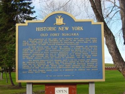
The promontory at the outlet of the Niagara River into Lake Ontario was a strategic point for controlling the route to the interior Great Lakes region. The French early recognized its importance, and LaSalle, in 1678, and Denonville. In 1687, erected temporary fortifications.
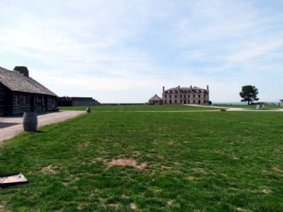
In 1726 DeLery built, for the fur trade, Fort Niagara, an imposing structure with massive stone walls. Resembling a French chateau, it was called "The Castle." The fortification irritated the British as rivalry with France for control of North America intensified. Captain Pouchot, a French engineer, strengthened the fort in anticipation of a British attack. British troops, with colonials and Indians, assaulted it, and, after an 18-day siege, Sir William Johnson forced the French to surrender, July 25, 1759.
The British improved Fort Niagara, used it for fur trading, and, during the American Revolution, made it their base for raiding the New York frontier. They did not relinquish it until 1796. Following an American invasion of Canada in the War of 1812, British forces again captured Fort Niagara on December 19, 1813. The peace treaty of 1814 returned the fort to the United States.
Old Fort Niagara stands today as a memorial to soldiers who served here under three flags.
Erected 1987 by New York State Education Department.
Topics and series. This historical marker is listed in these topic lists: Forts and Castles • War of 1812 • War, US Revolutionary. In addition, it is included in the Historic New York State series list. A significant historical date for this entry is July 25, 1970.
Location. 43° 15.717′ N, 79° 3.662′ W. Marker is near Youngstown, New York, in Niagara County. Marker can be reached from Scott Avenue. Located at Fort Niagara State Park. Touch for map. Marker is in this post office area: Youngstown NY 14174, United States of America. Touch for directions.
Other nearby markers. At least 8 other markers are within walking distance of this marker. The Niagara Portage: Gateway to the West (a few steps from this marker); Old Fort Niagara Lighthouse (within shouting distance of this marker); Morrow Plaza (within shouting distance of this marker); The Siege of Fort Niagara (within shouting distance of this marker); Dueling Cannons (within shouting distance of this marker); Old Fort Niagara Cannon (within shouting distance of this marker); a different marker also named Old Fort Niagara (within shouting distance of this marker); To the Memory (about 400 feet away, measured in a direct line). Touch for a list and map of all markers in Youngstown.
Also see . . .
1. Old Fort Niagara. Fort website homepage:
Western New York's most popular historic state park (Submitted on February 11, 2012, by Mike Wintermantel of Pittsburgh, Pennsylvania.)
2. Fort Niagara State Park. New York State Office of Parks, Recreation & Historic Preservation website entry (Submitted on February 11, 2012, by Mike Wintermantel of Pittsburgh, Pennsylvania.)
Credits. This page was last revised on January 3, 2022. It was originally submitted on February 11, 2012, by Mike Wintermantel of Pittsburgh, Pennsylvania. This page has been viewed 1,315 times since then and 26 times this year. Photos: 1. submitted on February 11, 2012, by Mike Wintermantel of Pittsburgh, Pennsylvania. 2, 3, 4. submitted on January 16, 2014, by Duane Hall of Abilene, Texas.


