Front Street District in Hartford in Capitol Region, Connecticut — The American Northeast (New England)
Front Street
Photographed by Michael Herrick, February 1, 2012
1. Front Street Marker
Inscription.
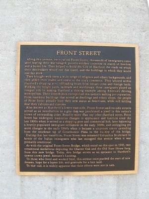
Front Street. . Along this avenue, once called Front Street, thousands of immigrants came after leaving their war-ravaged, poverty-stricken countries in search of freedom and a better life. They helped to build the City of Hartford, the roads on which their descendants would one day travel, and the buildings in which they would one day work. , They brought with them a wide range of religious and ethnic backgrounds, and they added their trades and crafts to the city's commerce. They labored within Hartford's shipping port, offloading boats from distant cities and foreign lands. Working the freight yards, railroads and warehouses, these immigrants played an integral role in making Hartford a shining example among America's thriving metropolises. Their contribution exemplified this nation's melting pot reputation. From tenement buildings that served as dwellings and ethnic shops, the people of Front Street proudly bore their new status as Americans, while still holding dear their cultures and customs. , Also known as Hartford's lower east side, Front Street and its side streets served as an introduction to a city that was proclaimed a jewel in this nation's crown of outstanding cities. Possibly more than any other street, Front Street has undergone numerous changes in appearance and function since the late 1800s when it served as a shipping port and commercial hub, later becoming a heavily-populated immigrant settlement in the early 1900s, and undergoing yet more changes in the early 1960s when it became a corporate center extending from the southeast tip of Constitution Plaza to the vicinity of this bridge. During that last transition, Front Street was renamed Columbus Boulevard in honor of the Italian immigrants who last occupied this avenue when it was primarily residential. , As with the original Front Street Bridge, which stood on this spot in 1941, two ornamental medallions depicting the Charter Oak and the Old State House hang from this new bridge. Today, this bridge serves as an entrance to Hartford's newest crown jewel: Adriaen's Landing. , To those who lived and worked here, this avenue once marked the start of new dreams, hope for a better life, and gratitude for a free land. , To that end, it is widely apparent that their efforts were not in vain.
Along this avenue, once called Front Street, thousands of immigrants came after leaving their war-ravaged, poverty-stricken countries in search of freedom and a better life. They helped to build the City of Hartford, the roads on which their descendants would one day travel, and the buildings in which they would one day work.
They brought with them a wide range of religious and ethnic backgrounds, and they added their trades and crafts to the city's commerce. They labored within Hartford's shipping port, offloading boats from distant cities and foreign lands. Working the freight yards, railroads and warehouses, these immigrants played an integral role in making Hartford a shining example among America's thriving metropolises. Their contribution exemplified this nation's melting pot reputation. From tenement buildings that served as dwellings and ethnic shops, the people of Front Street proudly bore their new status as Americans, while still holding dear their cultures and customs.
Also known as Hartford's lower east side, Front Street and its side streets served as an introduction to a city that was proclaimed a jewel
Click or scan to see this page online
in this nation's crown of outstanding cities. Possibly more than any other street, Front Street has undergone numerous changes in appearance and function since the late 1800s when it served as a shipping port and commercial hub, later becoming a heavily-populated immigrant settlement in the early 1900s, and undergoing yet more changes in the early 1960s when it became a corporate center extending from the southeast tip of Constitution Plaza to the vicinity of this bridge. During that last transition, Front Street was renamed Columbus Boulevard in honor of the Italian immigrants who last occupied this avenue when it was primarily residential.
As with the original Front Street Bridge, which stood on this spot in 1941, two ornamental medallions depicting the Charter Oak and the Old State House hang from this new bridge. Today, this bridge serves as an entrance to Hartford's newest crown jewel: Adriaen's Landing.
To those who lived and worked here, this avenue once marked the start of new dreams, hope for a better life, and gratitude for a free land.
To that end, it is widely apparent that their efforts were not in vain.
Topics.
Photographed by Michael Herrick, February 1, 2012
2. Front Street Marker
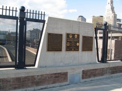
The Front Street marker is on the right
This historical marker is listed in these topic lists: Notable Places • Roads & Vehicles. A significant historical year for this entry is 1941.
Location. 41° 45.686′ N, 72° 40.23′ W. Marker is in Hartford in Capitol Region, Connecticut. It is in the Front Street District. It is at the intersection of Columbus Boulevard and Arch Street, on the right when traveling south on Columbus Boulevard. Located on the Maj. Thomas Y. Seymour Memorial Bridge. Touch for map. Marker is in this post office area: Hartford CT 06103, United States of America. Touch for directions.
Regionally, this marker is in the Connecticut River Valley and in the Knowledge Corridor. It is also in the American Northeast and in New England. Globally, it is in the North Atlantic Region, North America, the Western Hemisphere, the Western World, and the Anglosphere. Historically, it finds itself in what was once Hartford County and also one of the original Thirteen Colonies.
More about this marker. The Maj. Thomas Y. Seymour Memorial Bridge carries Columbus Boulevard (formerly called Front Street) over the Conlin-Whitehead Highway
Credits. This page was last revised on May 19, 2026. It was originally submitted on February 12, 2012, by Michael Herrick of Southbury, Connecticut. This page has been viewed 1,113 times since then and 47 times this year. Photos:1, 2. submitted on February 12, 2012, by Michael Herrick of Southbury, Connecticut. • Bill Pfingsten was the editor who published this page.