Middletown in Frederick County, Maryland — The American Northeast (Mid-Atlantic)
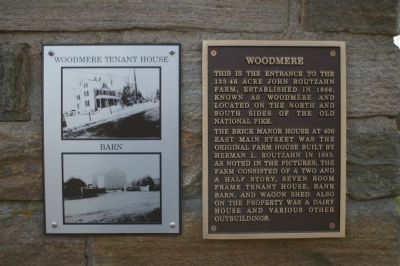
Woodmere
The brick manor house at 400 East Main Street was the original farm house built by Herman L. Routzahn in 1883. As noted in the pictures, the farm consisted of a two and a half story, seven room frame tenant house, bank barn, and wagon shed. Also on the property was a dairy house and other outbuildings.
Topics. This historical marker is listed in this topic list: Notable Buildings. A significant historical year for this entry is 1866.
Location. 39° 26.44′ N, 77° 32.103′ W. Marker is in Middletown, Maryland, in Frederick County. Marker is on East Main Street / Old National Road (Alternate U.S. 40), on the left when traveling west. Touch for map. Marker is at or near this postal address: 400 East Main Street, Middletown MD 21769, United States of America. Touch for directions.
Other nearby markers. At least 8 other markers are within walking distance of this marker. Charlie Keller (approx. half a mile away); Christ Reformed Church (approx. 0.6 miles away); Memorial Hall (approx. 0.6 miles away); Middletown (approx. 0.6 miles away); The Arnett Building (approx. 0.6 miles away); The Coblentz-Long Building (approx. 0.6 miles away); 8 West Main Street (approx. 0.6 miles away); Clovinger House (approx. 0.6 miles away). Touch for a list and map of all markers in Middletown.
More about this marker. To the left of the marker is a plate displaying photos of the tenant house and barn.
Additional keywords. "National Road" "Frederick County" Middletown
Credits. This page was last revised on June 16, 2016. It was originally submitted on February 11, 2008, by Christopher Busta-Peck of Shaker Heights, Ohio. This page has been viewed 2,019 times since then and 34 times this year. Photos: 1, 2. submitted on February 11, 2008, by Christopher Busta-Peck of Shaker Heights, Ohio. • Craig Swain was the editor who published this page.

