Berkeley Hills in Alameda County, California — The American West (Pacific Coastal)
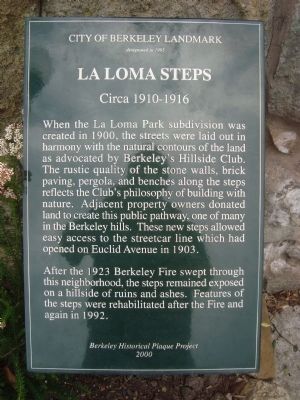
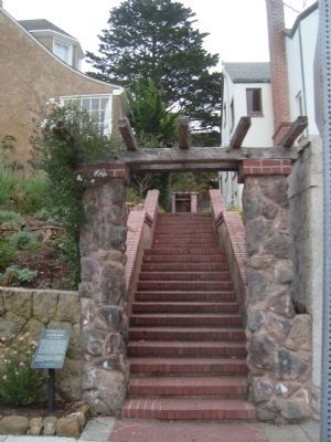
La Loma Steps
Circa 1910-1916
designated in 1995
After the 1923 Berkeley Fire swept through this neighborhood, the steps remained exposed on a hillside of ruins and ashes. Features of the steps were rehabilitated after the Fire and again in 1992.
Erected 2000 by Berkeley Historical Plaque Project.
Topics. This historical marker is listed in this topic list: Environment. A significant historical year for this entry is 1995.
Location. 37° 52.912′ N, 122° 15.623′ W. Marker is in Berkeley, California, in Alameda County. It is in Berkeley Hills. Marker is at the intersection of Le Roy Avenue and Hawthorne Terrace on Le Roy Avenue. Touch for map. Marker is at or near this postal address: 1497 Le Roy Avenue, Berkeley CA 94708, United States of America. Touch for directions.
Other nearby markers. At least 8 other markers are within walking distance of this marker. Hillside School (about 400 feet away, measured in a direct line); Rose Walk (about 600 feet away); Annie and Bernard Maybeck House (approx. 0.2 miles away); Temple of Wings (approx. ¼ mile away); Berkeley Municipal Rose Garden (approx. ¼ mile away); Robert Hale Merriman Residence (approx. ¼ mile away); Jensen House (approx. ¼ mile away); Daley’s Scenic Park Street Improvenents (approx. 0.3 miles away). Touch for a list and map of all markers in Berkeley.
Also see . . . The Hillside Club - history. The club's stated mission was "to protect the hills of Berkeley from unsightly grading and the building of unsuitable and disfiguring houses; to do all in our power to beautify these hills and above all to create and encourage a decided public opinion on these subjects." (Submitted on March 25, 2012, by Barry Swackhamer of Brentwood, California.)
Credits. This page was last revised on February 7, 2023. It was originally submitted on March 25, 2012, by Barry Swackhamer of Brentwood, California. This page has been viewed 676 times since then and 30 times this year. Photos: 1, 2. submitted on March 25, 2012, by Barry Swackhamer of Brentwood, California. • Syd Whittle was the editor who published this page.

