Manteo in Dare County, North Carolina — The American South (South Atlantic)
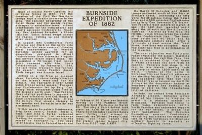
Burnside Expedition of 1862
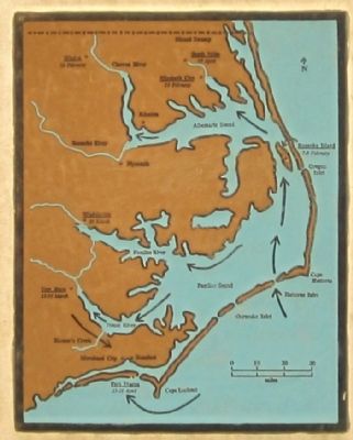
In August 1861 Confederate Forts Hatteras and Clark on the north side of Hatteras Inlet were overrun following naval bombardment. In October Burnside gained approval for an expedition designed to divert Confederate from tidewater Virginia and disrupt inland supply lines. He assembled a 78-vessel fleet under joint command with Adm. Louis Goldsborough. By February 1, 1862, the last troop transport was “across the swash,” inside Pamlico Sound. Their target was Roanoke Island.
Acting on a tip from an escaped slave, Burnside chose Ashby’s Harbor on the island’s west side for his assault. On February 7 over 7,500 Union troops moved ashore. The next day Confederates led by Brig. Gen. Henry Wise withdrew under fire to the island’s north end. The Federal feet shelled positions in support of the land offensive and Col. Henry M. Shaw surrendered 2,488 men. It was the Union’s first sizable victory in ten months and Burnside briefly was a national hero.
Within weeks Burnside’s lieutenants, Brig. Gens. John G. Foster, Jesse L. Reno, and John G. Parke, extended Union control into the waterways feeding the sounds. Elizabeth City was seized on February 10. Two days later Edenton was in Federal hands and on February 20 Winton was burned. Moving up the Pamlico River, gunboats took Washington on March 20. The single Union defeat took place on April 19 at South Mills, where Confederates repelled Reno’s men, foiling their attempt to demolish the Dismal Swamp Canal locks. The next target was the state’s second largest city, New Bern (1860 pop. 5,432).
On March 12 Burnside and 11,000 troops anchored south of New Bern at Slocum’s Creek. Defending the city were fortifications lining the Neuse River and 4,000 untested Confederates led by Brig. Gen. Lawrence O’B. Branch. The Federals went ashore on March 13 and, the next day, marched north along the Atlantic and North Carolina Railroad. Assisted by fire from the flotilla, Union troops broke the center of the Confederate line. The four-hour battle left 90 Union and 68 Confederate soldiers dead. After a full-scale retreat across the Trent River, New Bern was occupied. Many residents had fled in anticipation of the invasion.
The next objective was Fort Macon. Parke organized the assault, marching his men along the rail line from New Bern to Morehead City. Col. Moses J. White defended the fort with 54 cannon. Federals laid siege to the fort in late March, moving their artillery to within 1,500 yards of its walls. Crowds at the docks in Morehead City and Beaufort witnessed the shelling on April 25. The white flag appeared late that day and surrender was arranged on April 26. Access to the deepwater harbor at Beaufort spared the Federals the need to rely on the treacherous inlet at Hatteras.
In July, on orders from President Abraham Lincoln, Burnside moved most of his troops to Virginia to assist in a planned assault on Richmond. Burnside had hoped to rally Union sympathizers within North Carolina and undermine support for the war effort, a dream that went unrealized. The Burnside Expedition spurred Confederate recruiting and steeled the determination of North Carolina’s political and military leaders to assemble an effective fighting force.
Topics. This historical marker is listed in this topic list: War, US Civil. A significant historical date for this entry is February 1, 1862.
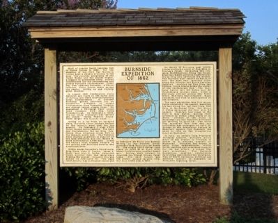
Location. 35° 53.141′ N, 75° 40.101′ W. Marker is in Manteo, North Carolina, in Dare County. Marker can be reached from Visitors Center Circle near Virginia Dare Memorial Bridge (Bypass U.S. 64), on the left when traveling west. Located at the Outer Banks Visitor Center. Touch for map. Marker is at or near this postal address: 1 Visitors Center Circle, Manteo NC 27954, United States of America. Touch for directions.
Other nearby markers. At least 8 other markers are within 2 miles of this marker, measured as the crow flies. Bowser Family Cemetery (here, next to this marker); Red Wolf Country (within shouting distance of this marker); Andrew Cartwright (approx. half a mile away); Battle of Roanoke Island (approx. half a mile away); Confederate Channel Obstructions (approx. 1.4 miles away); Fort Bartow (approx. 1.4 miles away); Spirit of Roanoke Island (approx. 1.6 miles away); USLSS/USCG Station Pea Island Memorial (approx. 1.6 miles away). Touch for a list and map of all markers in Manteo.
Credits. This page was last revised on June 16, 2016. It was originally submitted on June 30, 2012, by Bernard Fisher of Richmond, Virginia. This page has been viewed 1,093 times since then and 43 times this year. Photos: 1, 2, 3, 4. submitted on June 30, 2012, by Bernard Fisher of Richmond, Virginia.


