Chelsea in Manhattan in New York County, New York — The American Northeast (Mid-Atlantic)
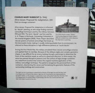
Charles Mary Kubricht (b. 1946)
Alive-nesses: Proposal for Adaption, 2011
| — | Paint on storage containers | — |
Photographed by Barry Swackhamer, May 18, 2012
1. Charles Mary Kubricht (b. 1946) Marker
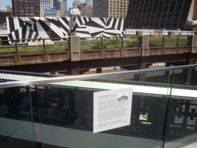
During the First World War, the military emulated these natural camouflage schemes and applied them to warships. Because of the oblique angles and complex geometric shapes, it was difficult for an enemy looking through a periscope to determine the front of the maritime vessel, as well as its speed and direction. In Alive-nesses, the artist has painted disruptive patterns over the surface of large storage containers at a waterfront location that echoes the original maritime application of this military camouflage technique. The patterns reorganize the perceived form of the containers,
this page online
This High Line Art Commission presented by Friends of the High Line and the New York City Department of Parks & Recreation. High Line Art Commissions are made possible by Donald R. Mullen, Jr. This program is supported, in part, with public funds from the New York City Department of Cultural Affairs in partnership with the City Council and from the New York State Council of the Arts.
Topics. This historical marker is listed in these topic lists: Arts, Letters, Music • War, World I. A significant historical year for this entry is 1914.
Location. 40° 45.139′ N, 74° 0.123′ W. Marker is in Manhattan, New York, in New York County. It is in Chelsea. It is on West 30th Street. This marker is located near the (currently) north end, 30th Street entrance to the High Line Elevated Park. Touch for map. Marker is in this post office area: New York NY 10001, United States of America. Touch for directions.

Regionally, this marker is in New York City. It is also in the American Northeast, in the Mid-Atlantic, and on the Eastern Seaboard.
Photographed by Barry Swackhamer, May 18, 2012
2. Charles Mary Kubricht (b. 1946) Marker
Alive-nesses : Proposal for Adaptation storage containers in the background.
Other nearby markers. At least 8 other markers are within walking distance of this marker: High Line (about 300 feet away, measured in a direct line); Death Avenue (about 400 feet away); Neighborhood Seniors (about 500 feet away); P.O. David Willis Basketball Court (approx. 0.2 miles away); Master Printers Building (approx. 0.2 miles away); Hudson River Railroad (approx. 0.2 miles away); Alice's Garden (approx. ¼ mile away); Chelsea Doughboy Statue (approx. ¼ mile away). Touch for a list and map of all markers in Manhattan.
Also see . . .
1. That Old Razzle Dazzle - The Economist. In the Second World War, many Allied ships were painted with dark and light stripes, and other contrasting shapes, making them look a bit like zebra. The idea was to distort an enemy submarine commander’s perception of the ship’s size, shape, range, heading and speed, so as to make it harder to hit with the non-homing torpedoes of the period. (Submitted on July 2, 2012, by Barry Swackhamer of Brentwood, California.)
2. High Line. The High Line was built in the 1930s, as part of a massive public-private infrastructure project called the West Side Improvement. It lifted freight traffic 30 feet in the air, removing dangerous trains from the streets of Manhattan's largest industrial district. No trains have run on the High Line since 1980. Friends of the High Line, a community-based non-profit group, formed in 1999 when the historic structure was under threat of demolition. Friends of the High Line works in partnership with the City of New York to preserve and maintain the structure as an elevated public park. (Submitted on July 2, 2012, by Barry Swackhamer of Brentwood, California.)
Additional keywords. razzle dazzle camouflage
Credits. This page was last revised on March 3, 2025. It was originally submitted on July 2, 2012, by Barry Swackhamer of Brentwood, California. This page has been viewed 647 times since then and 27 times this year. Photos: 1, 2. submitted on July 2, 2012, by Barry Swackhamer of Brentwood, California. • Bill Pfingsten was the editor who published this page.
