Lewiston in Niagara County, New York — The American Northeast (Mid-Atlantic)
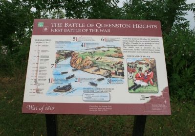
The Battle of Queenston Heights
First Battle of the War
— War of 1812 —
The Battle was a disaster for the Americans, as they suffered heavy losses and ultimately surrendered to the British.
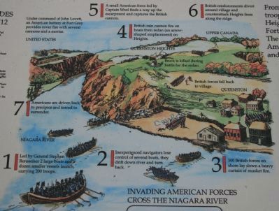
1) Led by General Stephen Van Rensselaer 2 large boats and a dozen smaller vessels launch, carrying 200 troops.
2) Inexperienced navigators lose control of several boats, they drift down river and turn back.
3) 300 British forces on shore lay down a heavy curtain of musket fire.
4) British rain cannon fire on boats from redan (an arrow shaped emplacement) on Heights.
5) A small American force led by captain Wool finds a way up the escarpment and captures the British cannon.
Under command of John Lovett, an American battery at Fort Grey provides cover fire with several cannons and a motar.
6) British reinforcements divert around village and counterattack Heights from along the ridge.
7) Americans are driven back to precipice and forced to surrender.
90 killed, approximately 1,000 captured.
British losses:
130 killed, wounded, or missing
October 13, 1812
3 AM - First American troops land on Canadian shore.
4 AM - Americans charge the Heights but are repelled.
6 AM - Second wave of American Troops lands.
8 AM - Captain Wool attacks redan from the rear.
9 AM - Americans force British from Heights and raise flag.
10 AM - British General Brock orders reinforcements and counterattacks.
11 AM - Americans repel the attack and Brock is killed
12 Noon - Americans secure landing and control the battlefield.
1 PM - Americans appear to be victorious
2 PM - General Van Rensselaer returns to Lewiston to rally the militia
4 PM - British reinforcements arrive from Ft. George and attack the Heights.
4 PM - American Militia reinforcements refuse to cross river.
6 PM - American Colonel Scott surrenders.
Erected by Great Lakes Seaway Trail.
Topics and series. This historical marker is listed in this topic list: War of 1812. In addition, it is included in the Great Lakes Seaway Trail National Scenic Byway series list. A significant historical month for this entry is October 1918.
Location. 43° 10.394′ N, 79° 2.953′ W. Marker is in Lewiston, New York, in Niagara County. Marker is on Center Street west of North Water Street, on the right when traveling west. This historic
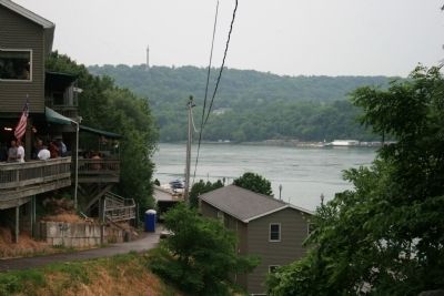
marker in a community park, that is located along the American shoreline of the Niagara River. It is situated along the roadway/walkway that runs down to the Niagara River. Touch for map. Marker is in this post office area: Lewiston NY 14092, United States of America. Touch for directions.
Other nearby markers. At least 8 other markers are within walking distance of this marker. A different marker also named The Battle of Queenston Heights (here, next to this marker); Freedom Crossing Monument (within shouting distance of this marker); a different marker also named Freedom Crossing Monument (within shouting distance of this marker); Barton House (approx. 0.2 miles away); Hennepin Park (approx. ¼ mile away); The Cibola Anchor (approx. 0.4 miles away); Little Yellow House - 1816 (approx. 0.4 miles away); Kiwanians Promoting Peace (approx. 0.4 miles away). Touch for a list and map of all markers in Lewiston.
Also see . . .
1. The Battle for Queenston Heights. This is a link to information provided by a War of 1812 site. (Submitted on July 3, 2012, by Dale K. Benington of Toledo, Ohio.)
2. Battle of Queenston Heights, 13 October 1812. This is a link to information provided by Wikipedia, the free encyclopedia. (Submitted on July 3, 2012, by Dale K. Benington of Toledo, Ohio.)
Credits. This page was last revised on June 16, 2016. It was originally submitted on July 2, 2012, by Dale K. Benington of Toledo, Ohio. This page has been viewed 1,067 times since then and 33 times this year. Photos: 1, 2, 3, 4, 5. submitted on July 3, 2012, by Dale K. Benington of Toledo, Ohio.
