Weatherford in Parker County, Texas — The American South (West South Central)
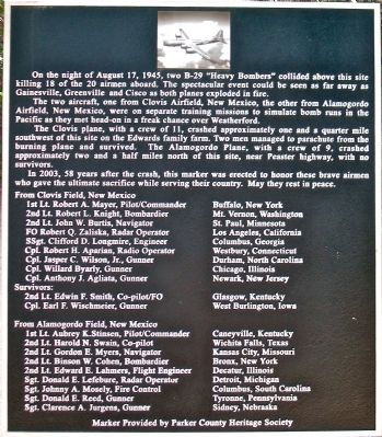
August 17, 1945 B-29 Crash
The two aircraft, one from Clovis Airfield, New Mexico, the other from Alamogordo Airfield, New Mexico, were on separate training missions to simulate bomb runs in the Pacific as they met head-on in a freak chance over Weatherford.
The Clovis plane, with a crew of 11, crashed approximately one and a quarter mile southwest of this site on the Edwards family farm. Two men managed to parachute from the burning plane and survived. The Alamogordo plane, with a crew of 9, crashed approximately two and a half miles north of this site, near Peaster highway, with no survivors.
In 2003, 58 years after the crash, this marker was erected to honor these brave airmen who gave the ultimate sacrifice while serving their country. May they rest in peace.
From Clovis Field, N.M.:
1st Lt. Robert A. Mayer, Pilot/Commander, Buffalo, New York
2nd Lt. Robert L. Knight, Bombardier, Mt. Vernon, Washington
2nd Lt. John W. Burtis, Navigator, St. Paul, Minnesota
FO Robert Q. Zaliska, Radar Operator, Los Angeles, California
SSgt. Clifford D. Longmire, Engineer, Columbus, Georgia Cpl. Robert H. Apirian, Radio Operator, Waterbury, Connecticut
Cpl. Jasper C. Wilson, Jr., Gunner, Durham, North Carolina
Cpl. Willard Byarly, Gunner, Chicago, Illinois
Cpl. Anthony J. Agliata, Gunner, Newark, New Jersey.
Survivors:
2nd Lt. Edwin F. Smith, Co-pilot/FO, Glasgow, Kentucky
Cpl. Earl F. Wischmeier, Gunner, West Burlington, Iowa
From Alamogordo Field:
1st Lt. Aubrey K. Stinsen, Pilot/Commander, Caneyville, Kentucky
2nd Lt. Harold N. Swain, Co-Pilot, Wichita Falls, Texas
2nd Lt. Gordon E. Myers, Navigator, Kansas City, Missouri
2nd Lt. Binson W. Cohen, Bombardier, Bronx, New York City
2nd Lt. Edward E. Lahmers, Flight Engineer, Decatur, Illinois
Sgt. Donald E. Lefebure, Radar Operator, Detroit, Michigan
Sgt. Johnny A. Mosely, Fire Control, Columbus, South Carolina
Sgt. Donald E. Reed, Gunner, Tyrone, Pennsylvania
Sgt. Clarence A. Jurgens, Gunner, Sidney, Nebraska
Erected 2003 by Parker County Heritage Society.
Topics. This historical marker is listed in these topic lists: Air & Space • Disasters • War, World II. A significant historical year for this entry is 1945.
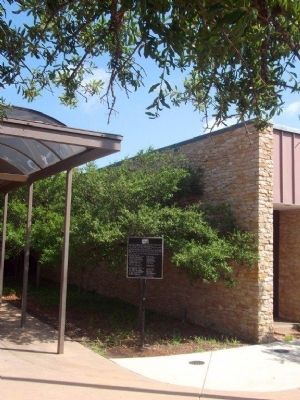
Location. 32° 44.709′ N, 97° 48.795′ W. Marker is in Weatherford, Texas, in Parker County. Marker can be reached from Charles Street, 0.2 miles east of South Bowir Drive, on the left when traveling north. Marker is at the pedestrian entrance to the Weatherford Public Library. Touch for map. Marker is at or near this postal address: 1014 Charles St, Weatherford TX 76086, United States of America. Touch for directions.
Other nearby markers. At least 8 other markers are within 2 miles of this marker, measured as the crow flies. Grace First Presbyterian Church (about 600 feet away, measured in a direct line); Parker County Gold Star Family Memorial Monument (approx. ¼ mile away); Soldier Spring Park (approx. ¼ mile away); Chandor Gardens (approx. ¾ mile away); Mount Pleasant Colored School (approx. 0.8 miles away); Governor S.W.T. Lanham (approx. 0.9 miles away); Central Christian Church (approx. 0.9 miles away); Twentieth Century Club (approx. 1.1 miles away). Touch for a list and map of all markers in Weatherford.
Also see . . . Tragedy over Weatherford. The 1945 night-time collision of two B-29 Superfortress Bombers (Submitted on July 17, 2012, by Bernard Fisher of Richmond, Virginia.)
Credits. This page was last revised on June 16, 2016. It was originally submitted on July 16, 2012, by Robert Dorr of Waterbury, Connecticut. This page has been viewed 1,654 times since then and 101 times this year. Last updated on July 17, 2012, by Robert Dorr of Waterbury, Connecticut. Photos: 1, 2. submitted on July 16, 2012, by Robert Dorr of Waterbury, Connecticut. • Kevin W. was the editor who published this page.

