Duncan in Stephens County, Oklahoma — The American South (West South Central)
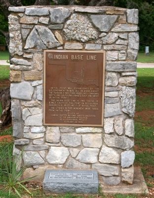
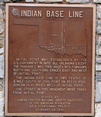
Indian Base Line
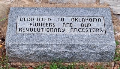
Dedicated to Oklahoma Pioneers and Our Revolutionary Ancestors
The Indian Base Line is two-tenths of a mile south of this point on Beech Road. Duncan is 41 miles west of Initial Point.
The stones in this monument were taken from Initial Point.
Placed by Duncan Chapter, National Society Daughters of the American Revolution as a Bicentennial Project
February 22, 1974
Erected 1974 by Duncan Chapter, Daughters of the American Revolution.
Topics and series. This historical marker is listed in this topic list: Political Subdivisions. In addition, it is included in the Daughters of the American Revolution series list. A significant historical month for this entry is February 1779.
Location. 34° 30.554′ N, 97° 58.04′ W. Marker is in Duncan, Oklahoma, in Stephens County. Marker is on U.S. 81, 0.1 miles south of West Pine Avenue, on the right when traveling south. This is one of only a few monuments in Memorial Park which is located right next to a parking area. It is just to the south of the only parking lot directly off of US 81 in the park. Touch for map. Marker is in this post office area: Duncan OK 73533, United States of America. Touch for directions.
Other nearby markers. At least 8 other markers are within walking distance of this marker. Memorial Park (within shouting distance of this marker); Erle P. Halliburton (within shouting distance of this marker); Persian Gulf, Afghanistan & Iraq War Memorial (about 700 feet away, measured in a direct line); Duty, Honor and Country (about 700 feet away); Lest We Forget (approx. 0.2 miles away); Vietnam War (approx. 0.2 miles away); POW-MIA (approx. 0.2 miles away); Halliburton (approx. 0.2 miles away). Touch for a list and map of all markers in Duncan.
More about this marker. Memorial Park is a large park extending for 7-8 blocks along US 81 in the middle of Duncan, Oklahoma. It contains numerous monuments and memorials to veterans as well as historic events and figures. This memorial is, Team Blakelylaw believes, the most southerly one in the park.
Regarding Indian Base Line. Everyone who owns real property west of the Ohio-Pennsylvania border might be interested in this monument because all land in the US west of there is described in the same manner by ranges and townships. There were multiple of these "initial points" established throughout the US. Every inch of land west of the Point of Beginning in Ohio is described by reference to some initial point. Even those who live in the platted areas of cities and towns will find this type of description for their property if they go back far enough in the records.

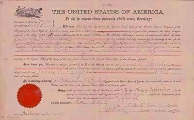
United States General Land Office, November 24, 1899
3. Oklahoma Homestead Claim Certificate
This homestead claim certificate, demonstrating the application of the initial surveying point as described on the marker, is made out to James N. Hughes, and grants him 160 acres, as described relative to the Indian Baseline (see map on marker): "Northwest quarter of Section Thirty-four in Township Seventeen North of Range and East of Indian Meridian in Oklahoma containing one hundred and sixty acres". This particular certificate is of additional interest because it was signed by President William McKinley, and made out to James N. Hughes, the father of the poet Langston Hughes.
Image courtesy of the Beinicke Library. (Click on image to enlarge.)
Image courtesy of the Beinicke Library. (Click on image to enlarge.)
Credits. This page was last revised on June 16, 2016. It was originally submitted on August 2, 2012, by M. Blakelylaw of Southeast, Oklahoma. This page has been viewed 679 times since then and 38 times this year. Photos: 1, 2. submitted on August 2, 2012, by M. Blakelylaw of Southeast, Oklahoma. 3. submitted on September 11, 2015. 4. submitted on August 2, 2012, by M. Blakelylaw of Southeast, Oklahoma. • Craig Swain was the editor who published this page.


