Boutte in St. Charles Parish, Louisiana — The American South (West South Central)
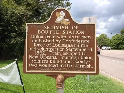
Skirmish of Boutte Station
Erected by St. Charles Parish Police Jury and St. Charles Bicentennial Committee.
Topics. This historical marker is listed in these topic lists: Railroads & Streetcars • War, US Civil. A significant historical month for this entry is September 1885.
Location. 29° 54.04′ N, 90° 23.3′ W. Marker is in Boutte, Louisiana, in St. Charles Parish. Marker is at the intersection of U.S. 90 and Magnolia Ridge Road, on the right when traveling east on U.S. 90. Touch for map. Marker is in this post office area: Boutte LA 70039, United States of America. Touch for directions.
Other nearby markers. At least 8 other markers are within 4 miles of this marker, measured as the crow flies. Hale Boggs Bridge (approx. 2.7 miles away); Destrehan Manor House (approx. 3.4 miles away); Destrehan Plantation (approx. 3.4 miles away); a different marker also named Hale Boggs Bridge (approx. 3.4 miles away); George Prince Ferry Memorial (approx. 3.4 miles away); St. Charles Borromeo "Little Red Church" (approx. 3˝ miles away); Mule Barn (approx. 3˝ miles away); Saint Charles Borromeo Church (approx. 3˝ miles away).
Credits. This page was last revised on June 16, 2016. It was originally submitted on August 9, 2012, by Renee Simpson of Hahnville, Louisiana. This page has been viewed 1,339 times since then and 102 times this year. Photo 1. submitted on August 9, 2012, by Renee Simpson of Hahnville, Louisiana. • Craig Swain was the editor who published this page.
Editor’s want-list for this marker. A wide view photo of the marker and the surrounding area in context. • Can you help?
