Near Dunn in Harnett County, North Carolina — The American South (South Atlantic)
Battle of Averasboro
Phase Two – March 16, 1865
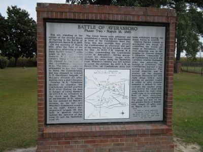
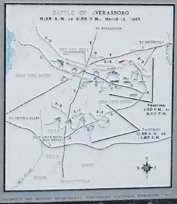
On the morning of March 16th, after the fight of the preceding afternoon around John Smith’s house 2 miles south on this road, Union General H.J. Kilpatrick’s cavalry found a back road (A) circled to the rear of the Confederate position (E-2). The Union cavalry (B) attempted to use this road to flank the Confederates, but was stopped by Colonel G.P. Harrison’s brigade of McLaw’s division (C) after moving only a short distance.
General W.B. Taliaferro decided to abandon the Confederate second position (E-2) after finding his men in danger of being flanked. At 1:00 P.M. he withdrew to the third and final line of earthworks (E-3), where he was assisted by McLaw’s division on his left and Wheeler’s dismounted cavalry on his right. Rhett’s disorganized brigade (D) was held in general reserve behind the junction of this road (E) and the Smithfield road (F).
The Union forces soon advanced and established a strong line (G) immediately in front of the Confederate third line. From this new position they pressed the Confederates all afternoon and part of the evening, but were unable to break the line. At 8:00 P.M. General W.J. Hardee, commanding the Confederate forces at Averasboro, having accomplished his objectives, began withdrawing his corps along the Smithfield road. Wheeler’s cavalry was left behind to cover the retreat. By 4:00 A.M. on March 17th, all Confederate units had been withdrawn leaving the Union forces in control.
General Hardee wished to accomplish two things by contesting the Union advance at Averasboro. The first objective was to determine for General Joseph E. Johnston, commander of all Confederate forces in the Carolinas, whether Sherman’s army was advancing on Raleigh or Goldsboro. The second objective was to stretch out the distance between Sherman’s left and right wings (which were moving on parallel roads) in order to give General Johnston a chance to concentrate his smaller army and destroy the Union left wing before the right wing could come to its assistance. Both of these objectives were fully accomplished. The stage was now set for the greater Battle of Bentonville, fought 25 miles east on March 19-21, 1865.
NOTE: In order to better understand the battle it is best to read the large map-marker “Phase One” which is located two miles south on this road.
Erected 1961 by Archives and Highway Departments. Confederate Centennial Commission.
Topics. This historical marker is listed in this topic list: War, US Civil. A significant historical date for this entry is March 15, 1804.
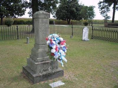
Location. 35° 15.8′ N, 78° 40.372′ W. Marker is near Dunn, North Carolina, in Harnett County. Marker is at the intersection of State Highway 82 and Magruder Road, on the right when traveling north on State Highway 82. Marker is located on Route 82, about 4 miles south of Dunn, NC. Marker is on the grounds of the Chicora Civil War Cemetery, just south of and across from the Averasboro Battlefield Museum. Touch for map. Marker is in this post office area: Dunn NC 28335, United States of America. Touch for directions.
Other nearby markers. At least 8 other markers are within walking distance of this marker. South Carolina Troops at Battle of Averasboro, NC (within shouting distance of this marker); North Carolina Troops (within shouting distance of this marker); Confederate Soldiers of McLaws Division (within shouting distance of this marker); a different marker also named Battle of Averasboro (within shouting distance of this marker); Men of South Carolina (within shouting distance of this marker); Chicora Cemetery (within shouting distance of this marker); Union Headquarters (about 400 feet away, measured in a direct line); Model 1841 6-pounder Gun (approx. 0.2 miles away). Touch for a list and map of all markers in Dunn.
Also see . . .
1. Averasboro Battlefield and Museum. (Submitted on March 1, 2008, by Bill Coughlin of Woodland Park, New Jersey.)
2. The Battle of Averasboro - March 16, 1865. Marion County in the War Between the States - SCGenWeb site. (Submitted on March 1, 2008, by Bill Coughlin of Woodland Park, New Jersey.)
Credits. This page was last revised on June 16, 2016. It was originally submitted on February 29, 2008, by Bill Coughlin of Woodland Park, New Jersey. This page has been viewed 2,872 times since then and 29 times this year. Photos: 1. submitted on February 29, 2008, by Bill Coughlin of Woodland Park, New Jersey. 2, 3. submitted on August 4, 2010, by Bill Coughlin of Woodland Park, New Jersey. 4, 5. submitted on February 29, 2008, by Bill Coughlin of Woodland Park, New Jersey. • Craig Swain was the editor who published this page.
