Cambridge in Washington County, New York — The American Northeast (Mid-Atlantic)
Site of Skirmish
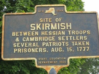
Photographed by Virginia McGreevy, August 16, 2012
1. Site of Skirmish Marker
Erected 1932 by New York State Education Department.
Topics. This historical marker is listed in this topic list: War, US Revolutionary. A significant historical date for this entry is August 15, 1777.
Location. 42° 58.253′ N, 73° 22.64′ W. Marker is in Cambridge, New York, in Washington County. It is on New York State Route 22 just south of County Route 68, on the right when traveling north. This marker is located in the parking lot of a garage. Touch for map. Marker is in this post office area: Cambridge NY 12816, United States of America. Touch for directions.

Regionally, this marker is in Upstate New York and in the Capital District. It is also in the American Northeast and in the Mid-Atlantic. Globally, it is in North America, the Great North Woods, the Western Hemisphere, the Western World, and the Anglosphere. Historically, it finds itself in what was once the Viceroyalty of New France, New Netherland, and one of the original Thirteen Colonies.
Other nearby markers. At least 8 other markers
this page online
Additional keywords. Burgoyne Campaign, Bennington Battle, 1777
Credits. This page was last revised on June 16, 2016. It was originally submitted on August 17, 2012, by Tom McGreevy of Averill Park, New York. This page has been viewed 989 times since then and 38 times this year. Photo 1. submitted on August 17, 2012, by Tom McGreevy of Averill Park, New York. • Bill Pfingsten was the editor who published this page.
