Argyle in Washington County, New York — The American Northeast (Mid-Atlantic)
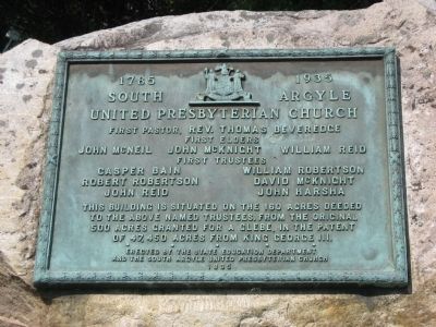
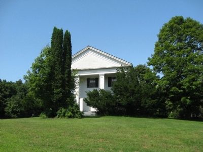
South Argyle United Presbyterian Church
1785 - 1935
Inscription.
First Pastor Rev. Thomas Beveredge
First Elders John McNeil John McKnight William Reid
First Trustees Casper Bain William Robertson Robert Robertson David McKnight John Reid John Harsha
Building is situated on the 160 acres deeded to the above named trustees from the original 500 acres granted for a Glebe in the Patent of 47,450 acres from King George III
Erected 1935 by State Education Department and the South Argyle United Presbyterian Church.
Topics. This historical marker is listed in this topic list: Churches & Religion.
Location. 43° 11.438′ N, 73° 27.687′ W. Marker is in Argyle, New York, in Washington County. Marker is at the intersection of County Route 49 and Lohret Road, on the left when traveling east on County Route 49. Touch for map. Marker is at or near this postal address: 1201-1299 County Road 49, Argyle NY 12809, United States of America. Touch for directions.
Other nearby markers. At least 8 other markers are within 6 miles of this marker, measured as the crow flies. The Family of John Allen (approx. 0.8 miles away); Allen Cabin (approx. 0.9 miles away); Argyle, New York War Memorial (approx. 3.6 miles away); Kilmer Mill (approx. 3.7 miles away); Stone Arch Bridge (approx. 3.7 miles away); Home and Laboratory of Dr. Asa Fitch, Jr. (approx. 5 miles away); Judge William Duer (approx. 5.7 miles away); Battenville (approx. 5.9 miles away). Touch for a list and map of all markers in Argyle.
Credits. This page was last revised on June 16, 2016. It was originally submitted on August 17, 2012, by Tom McGreevy of Averill Park, New York. This page has been viewed 679 times since then and 40 times this year. Photos: 1, 2. submitted on August 17, 2012, by Tom McGreevy of Averill Park, New York. • Bill Pfingsten was the editor who published this page.

